
Fai una donazione
Equipaggiati per la tua prossima avventura:
In qualità di Affiliato Amazon, questo sito riceve una commissione sugli acquisti idonei, senza costi aggiuntivi per l’utente.
Mappa topografica Mount Nebo
Clicca sulla mappa per visualizzare l'altitudine.
Fai una donazione
Equipaggiati per la tua prossima avventura:
In qualità di Affiliato Amazon, questo sito riceve una commissione sugli acquisti idonei, senza costi aggiuntivi per l’utente.
A proposito di questa mappa
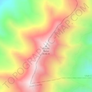
Nome: Mappa topografica Mount Nebo, altitudine, rilievo.
Luogo: Mount Nebo, Utah County, Utah, United States (39.82157 -111.76043 39.82167 -111.76033)
Altitudine media: 3’115 m
Altitudine minima: 2’507 m
Altitudine massima: 3’622 m
Fai una donazione
Equipaggiati per la tua prossima avventura:
In qualità di Affiliato Amazon, questo sito riceve una commissione sugli acquisti idonei, senza costi aggiuntivi per l’utente.
Altre mappe topografiche
Clicca su una mappa per visualizzarne la topografia, l'altitudine e il rilievo.
Orem
United States > Utah > Utah County
Orem is located at 40°17′56″N 111°41′47″W / 40.29889°N 111.69639°W / 40.29889; -111.69639 (40.298753, -111.696486). Situated in a high desert, with an average elevation of 4,756 feet. According to the United States Census Bureau, the city has a total area of 18.4 square miles (48 km2), all…
Altitudine media: 1’458 m
Fai una donazione
Equipaggiati per la tua prossima avventura:
In qualità di Affiliato Amazon, questo sito riceve una commissione sugli acquisti idonei, senza costi aggiuntivi per l’utente.
Provo
United States > Utah > Utah County
Provo lies in the Utah Valley at an elevation of 4,549 feet (1,387 m). According to the United States Census Bureau, the city has an area of 44.2 square miles (114.4 km2), of which 41.7 square miles (107.9 km2) is land and 2.5 square miles (6.5 km2), or 5.66%, is water.
Altitudine media: 1’728 m
Eagle Mountain
United States > Utah > Utah County
Eagle Mountain's climate varies drastically between the northeastern Ranches area and the southwestern City Center area. Despite being further south than Salt Lake City, both areas have cooler temperatures due to sitting at a higher elevation. The Ranches section of the city has slightly milder temperatures…
Altitudine media: 1’589 m
Fai una donazione
Equipaggiati per la tua prossima avventura:
In qualità di Affiliato Amazon, questo sito riceve una commissione sugli acquisti idonei, senza costi aggiuntivi per l’utente.
American Fork
United States > Utah > Utah County
The elevation is 4,566 feet (1,392 m) above sea level.
Altitudine media: 1’405 m
Fai una donazione
Equipaggiati per la tua prossima avventura:
In qualità di Affiliato Amazon, questo sito riceve una commissione sugli acquisti idonei, senza costi aggiuntivi per l’utente.
Mapleton
United States > Utah > Utah County
According to the United States Census Bureau, the city has a total area of 12.6 square miles (32.6 km2), all land. The community lies at an elevation of 4,700 feet (1,400 m) above sea level.
Altitudine media: 1’682 m
Saratoga Springs
United States > Utah > Utah County
Saratoga Springs is a city in Utah County, Utah, United States. The elevation is 4,505 feet. It is part of the Provo–Orem, Utah Metropolitan Statistical Area. The city is a relatively new development along the northwestern shores of Utah Lake. It was incorporated on December 31, 1997 and has been growing…
Altitudine media: 1’495 m
Fai una donazione
Equipaggiati per la tua prossima avventura:
In qualità di Affiliato Amazon, questo sito riceve una commissione sugli acquisti idonei, senza costi aggiuntivi per l’utente.
Provo
United States > Utah > Utah County
Provo lies in the Utah Valley at an elevation of 4,549 feet (1,387 m). According to the United States Census Bureau, the city has an area of 44.2 square miles (114.4 km2), of which 41.7 square miles (107.9 km2) is land and 2.5 square miles (6.5 km2), or 5.66%, is water.
Altitudine media: 1’728 m
Fai una donazione
Equipaggiati per la tua prossima avventura:
In qualità di Affiliato Amazon, questo sito riceve una commissione sugli acquisti idonei, senza costi aggiuntivi per l’utente.
Provo
United States > Utah > Utah County
Provo lies on the eastern bank of Utah Lake in Utah Valley at an elevation of 4,549 feet (1,387 m). According to the United States Census Bureau, the city has an area of 44.2 square miles (114.4 km2), of which 41.7 square miles (107.9 km2) is land and 2.5 square miles (6.5 km2), or 5.66%, is water.
Altitudine media: 1’728 m
Eagle Mountain
United States > Utah > Utah County
Eagle Mountain's climate varies drastically between the northeastern Ranches area and the southwestern City Center area. Despite being further south than Salt Lake City, both areas have cooler temperatures due to sitting at a higher elevation. The Ranches section of the city has slightly milder temperatures…
Altitudine media: 1’589 m
Fai una donazione
Equipaggiati per la tua prossima avventura:
In qualità di Affiliato Amazon, questo sito riceve una commissione sugli acquisti idonei, senza costi aggiuntivi per l’utente.
American Fork
United States > Utah > Utah County
Elevations throughout the city range from 4,566 feet (1,392 m) to 4,619 feet (1,408 m) above sea level.
Altitudine media: 1’405 m
Provo
United States > Utah > Utah County
Provo lies on the eastern bank of Utah Lake in Utah Valley at an elevation of 4,549 feet (1,387 m). According to the United States Census Bureau, the city has an area of 44.2 square miles (114.4 km2), of which 41.7 square miles (107.9 km2) is land and 2.5 square miles (6.5 km2), or 5.66%, is water.
Altitudine media: 1’728 m
Fai una donazione
Equipaggiati per la tua prossima avventura:
In qualità di Affiliato Amazon, questo sito riceve una commissione sugli acquisti idonei, senza costi aggiuntivi per l’utente.
Mapleton
United States > Utah > Utah County
According to the United States Census Bureau, the city has a total area of 12.6 square miles (32.6 km2), all land. The community lies at an elevation of 4,700 feet (1,400 m) above sea level.
Altitudine media: 1’682 m
Fai una donazione
Equipaggiati per la tua prossima avventura:
In qualità di Affiliato Amazon, questo sito riceve una commissione sugli acquisti idonei, senza costi aggiuntivi per l’utente.
Saratoga Springs
United States > Utah > Utah County
Saratoga Springs is a city in Utah County, Utah, United States. The elevation is 4,505 feet. It is part of the Provo–Orem, Utah Metropolitan Statistical Area. The city is a relatively new development along the northwestern shores of Utah Lake. It was incorporated on December 31, 1997 and has been growing…
Altitudine media: 1’500 m
Provo
United States > Utah > Utah County
Provo lies on the eastern bank of Utah Lake in Utah Valley at an elevation of 4,549 feet (1,387 m). According to the United States Census Bureau, the city has an area of 44.2 square miles (114.4 km2), of which 41.7 square miles (107.9 km2) is land and 2.5 square miles (6.5 km2), or 5.66%, is water.
Altitudine media: 1’728 m
Fai una donazione
Equipaggiati per la tua prossima avventura:
In qualità di Affiliato Amazon, questo sito riceve una commissione sugli acquisti idonei, senza costi aggiuntivi per l’utente.
Provo
United States > Utah > Utah County
Provo lies on the eastern bank of Utah Lake in Utah Valley at an elevation of 4,549 feet (1,387 m). According to the United States Census Bureau, the city has an area of 44.2 square miles (114.4 km2), of which 41.7 square miles (107.9 km2) is land and 2.5 square miles (6.5 km2), or 5.66%, is water.
Altitudine media: 1’728 m