
Mappa topografica Chelsham
Clicca sulla mappa per visualizzare l'altitudine.
A proposito di questa mappa
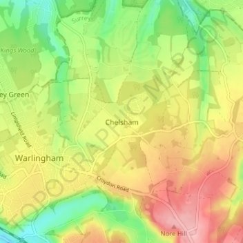
Nome: Mappa topografica Chelsham, altitudine, rilievo.
Altitudine media: 176 m
Altitudine minima: 106 m
Altitudine massima: 248 m
Altre mappe topografiche
Clicca su una mappa per visualizzarne la topografia, l'altitudine e il rilievo.
Warlingham
United Kingdom > England > Surrey > Chelsham
Elevations vary from 110m AOD at Woldingham Road, at the southernmost point of the parish, with a gentle increase in height through the village along the main road heading to the southeast, to the highest elevation (199.6m) at Limpsfield Road.
Altitudine media: 163 m