
Mappa topografica Godalming
Mappa interattiva
Clicca sulla mappa per visualizzare l'altitudine.
A proposito di questa mappa
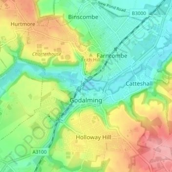
Nome: Mappa topografica Godalming, altitudine, rilievo.
Luogo: Godalming, Waverley, Surrey, England, United Kingdom (51.16986 -0.64093 51.20806 -0.58489)
Altitudine media: 71 m
Altitudine minima: 31 m
Altitudine massima: 133 m
Elevations vary between 36 m (118 ft) AOD by the Guildford Road Rugby Union ground and Broadwater lake at the River Wey's exit from Godalming into Peasmarsh, Shalford, and 106 m (348 ft) AOD where Quarter Mile meets Hambledon Road (both residential) in the south-east. Hurtmore Road is also residential: Upper Green/Hurtmore is at 102 m (335 ft) AOD. Immediately north and south of the town centre, steep hills reach 95 m (312 ft) AOD from 40–45 m (131–148 ft) AOD in the town centre itself.
Altre mappe topografiche
Clicca su una mappa per visualizzarne la topografia, l'altitudine e il rilievo.
Haslemere
United Kingdom > England > Surrey > Waverley
Haslemere, Waverley, Surrey, England, United Kingdom
Altitudine media: 150 m