
Mappa topografica Storrs
Clicca sulla mappa per visualizzare l'altitudine.
A proposito di questa mappa
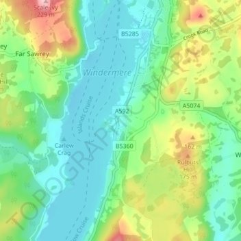
Nome: Mappa topografica Storrs, altitudine, rilievo.
Altitudine media: 93 m
Altitudine minima: 36 m
Altitudine massima: 226 m
Altre mappe topografiche
Clicca su una mappa per visualizzarne la topografia, l'altitudine e il rilievo.
Windermere
United Kingdom > England > Cumbria > South Lakeland > Bowness-on-Windermere
There is debate as to whether the stretch of water between Newby Bridge and Lakeside at the southern end of the lake should be considered part of Windermere, or a navigable stretch of the River Leven. This affects the stated length of the lake, which is 11.23 miles (18.07 km) long if measured from the bridge…
Altitudine media: 132 m