
Mappa topografica St Albans
Mappa interattiva
Clicca sulla mappa per visualizzare l'altitudine.
A proposito di questa mappa
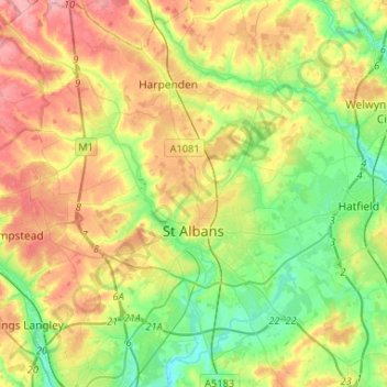
Nome: Mappa topografica St Albans, altitudine, rilievo.
Altitudine media: 107 m
Altitudine minima: 58 m
Altitudine massima: 175 m
St Albans was an ancient borough created following the dissolution of the monastery in 1539. It consisted of the ancient parish of St Albans (also known as the Abbey parish) and parts of St Michael and St Peter. The municipal corporation was reformed by the Municipal Corporations Act 1835 and the boundary was adjusted to additionally include part of the parish of St Stephen. In 1887 the borough gained city status, following the elevation of St Albans Abbey to cathedral, and the boundary was adjusted to include part of the parish of Sandridge.
Altre mappe topografiche
Clicca su una mappa per visualizzarne la topografia, l'altitudine e il rilievo.
Sandridge
United Kingdom > England > Hertfordshire > St Albans
Sandridge, St Albans, Hertfordshire, England, United Kingdom
Altitudine media: 105 m
Frogmore
United Kingdom > England > Hertfordshire > St Albans
Frogmore, St Albans, Hertfordshire, England, AL2 2LS, United Kingdom
Altitudine media: 80 m
Harpenden
United Kingdom > England > Hertfordshire > St Albans > Harpenden
Harpenden, St Albans, Hertfordshire, England, United Kingdom
Altitudine media: 119 m