
Mappa topografica Lawton
Mappa interattiva
Clicca sulla mappa per visualizzare l'altitudine.
A proposito di questa mappa
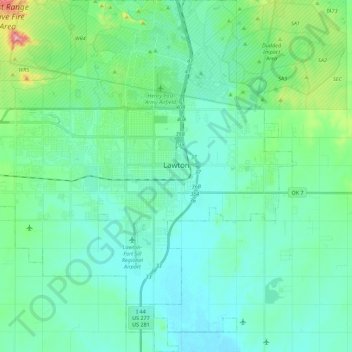
Nome: Mappa topografica Lawton, altitudine, rilievo.
Luogo: Lawton, Comanche County, Oklahoma, United States (34.51150 -98.53649 34.69435 -98.31443)
Altitudine media: 352 m
Altitudine minima: 314 m
Altitudine massima: 525 m
Developed on former reservation lands of the Kiowa, Comanche, and Apache Indians, Lawton was founded by European Americans on 6 August 1901. It was named after Major General Henry Ware Lawton, who served in the Civil War, where he earned the Medal of Honor, and was killed in action in the Philippine–American War. Lawton's landscape is typical of the Great Plains, with flat topography and gently rolling hills, while the area north of the city is marked by the Wichita Mountains.
Altre mappe topografiche
Clicca su una mappa per visualizzarne la topografia, l'altitudine e il rilievo.
Daly Hill
United States > Oklahoma > Comanche County
Daly Hill, Comanche County, Oklahoma, United States
Altitudine media: 396 m
Jackson Hole
United States > Oklahoma > Comanche County
Jackson Hole, Comanche County, Oklahoma, United States
Altitudine media: 406 m
South East Corner Landing Strip
United States > Oklahoma > Comanche County
South East Corner Landing Strip, Comanche County, Oklahoma, United States
Altitudine media: 383 m
Mount McKinley
United States > Oklahoma > Comanche County
Mount McKinley, Comanche County, Oklahoma, United States
Altitudine media: 498 m
Fort Sill
United States > Oklahoma > Comanche County
Fort Sill, Comanche County, Oklahoma, United States
Altitudine media: 417 m
Medicine Park
United States > Oklahoma > Comanche County > Medicine Park
Medicine Park, Comanche County, Oklahoma, 73557, United States
Altitudine media: 429 m