
Fai una donazione
Equipaggiati per la tua prossima avventura:
In qualità di Affiliato Amazon, questo sito riceve una commissione sugli acquisti idonei, senza costi aggiuntivi per l’utente.
Mappa topografica Willamette River
Clicca sulla mappa per visualizzare l'altitudine.
Fai una donazione
Equipaggiati per la tua prossima avventura:
In qualità di Affiliato Amazon, questo sito riceve una commissione sugli acquisti idonei, senza costi aggiuntivi per l’utente.
Willamette River
The Willamette River drains a region of 11,478 square miles (29,730 km2), which is 12 percent of the total area of Oregon. Bounded by the Coast Range to the west and the Cascade Range to the east, the river basin is about 180 miles (290 km) long and 100 miles (160 km) wide. Elevations within the watershed range from 10,495 feet (3,199 m) at Mount Jefferson in the Cascade Range to 10 feet (3.0 m) at the mouth on the Columbia River. Watersheds bordering the Willamette River basin are those of the Little Deschutes River to the southeast, the Deschutes River to the east, and the Sandy River to the northeast; the North Umpqua and Umpqua rivers to the south; coastal rivers including (from south to north) the Siuslaw, the Alsea, the Yaquina, the Siletz, the Nestucca, the Trask, and the Wilson to the west; the Nehalem and the Clatskanie to the northwest, and the Columbia River to the north.
Fai una donazione
Equipaggiati per la tua prossima avventura:
In qualità di Affiliato Amazon, questo sito riceve una commissione sugli acquisti idonei, senza costi aggiuntivi per l’utente.
A proposito di questa mappa
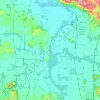
Nome: Mappa topografica Willamette River, altitudine, rilievo.
Luogo: Willamette River, Polk County, Oregon, United States (44.67991 -123.18023 44.83492 -123.09000)
Altitudine media: 72 m
Altitudine minima: 40 m
Altitudine massima: 290 m
Fai una donazione
Equipaggiati per la tua prossima avventura:
In qualità di Affiliato Amazon, questo sito riceve una commissione sugli acquisti idonei, senza costi aggiuntivi per l’utente.
Altre mappe topografiche
Clicca su una mappa per visualizzarne la topografia, l'altitudine e il rilievo.