
Mappa topografica Bozeman
Mappa interattiva
Clicca sulla mappa per visualizzare l'altitudine.
A proposito di questa mappa
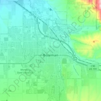
Nome: Mappa topografica Bozeman, altitudine, rilievo.
Luogo: Bozeman, Gallatin County, Montana, United States (45.63479 -111.11982 45.73326 -110.98424)
Altitudine media: 1’495 m
Altitudine minima: 1’392 m
Altitudine massima: 1’974 m
Bozeman is located at an elevation of 4,820 feet (1,470 m). The Bridger Mountains are to the north-northeast, the Tobacco Root Mountains to the west-southwest, the Big Belt Mountains and Horseshoe Hills to the northwest, the Hyalite Peaks of the northern Gallatin Range to the south and the Spanish Peaks of the northern Madison Range to the south-southwest. Bozeman is east of the continental divide, and Interstate 90 passes through the city. It is 84 miles (135 km) east of Butte, 125 miles (201 km) west of Billings, and 93 miles (150 km) north of Yellowstone National Park.
Altre mappe topografiche
Clicca su una mappa per visualizzarne la topografia, l'altitudine e il rilievo.
Belgrade
United States > Montana > Gallatin County
Belgrade, Gallatin County, Montana, 59714, United States
Altitudine media: 1’355 m
Lightning Lake
United States > Montana > Gallatin County
Lightning Lake, Gallatin County, Montana, United States
Altitudine media: 2’690 m
Big Sky
United States > Montana > Gallatin County
Big Sky, Gallatin County, Montana, United States
Altitudine media: 2’435 m
Bozeman
United States > Montana > Gallatin County > Bozeman
Bozeman, Gallatin County, Montana, 59715, United States
Altitudine media: 1’679 m
Springhill
United States > Montana > Gallatin County > Springhill
Springhill, Gallatin County, Montana, United States
Altitudine media: 1’491 m