
Mappa topografica Acadia National Park
Mappa interattiva
Clicca sulla mappa per visualizzare l'altitudine.
A proposito di questa mappa
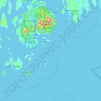
Nome: Mappa topografica Acadia National Park, altitudine, rilievo.
Altitudine media: 9 m
Altitudine minima: -3 m
Altitudine massima: 452 m
The ecological zones at Acadia National Park, from highest to lowest elevation, include: nearly barren mountain summits; northern boreal and eastern deciduous forests on the mountainsides; freshwater lakes and ponds, as well as wetlands like marshes and swamps in the valleys between mountains; and the Atlantic shoreline with rocky and sandy beaches, intertidal and subtidal zones.
Altre mappe topografiche
Clicca su una mappa per visualizzarne la topografia, l'altitudine e il rilievo.
Otter Cliffs
United States > Maine > Hancock County > Bar Harbor
Otter Cliffs, Bar Harbor, Hancock County, Maine, United States
Altitudine media: 13 m