
Mappa topografica Yard
Clicca sulla mappa per visualizzare l'altitudine.
A proposito di questa mappa
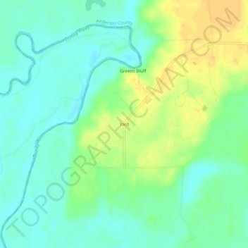
Nome: Mappa topografica Yard, altitudine, rilievo.
Luogo: Yard, Anderson County, Texas, United States (31.84155 -95.99108 31.88155 -95.95108)
Altitudine media: 78 m
Altitudine minima: 66 m
Altitudine massima: 94 m
Altre mappe topografiche
Clicca su una mappa per visualizzarne la topografia, l'altitudine e il rilievo.
Palestine
United States > Texas > Anderson County
About 40% of the content from the 2003 Space Shuttle Columbia disaster was recovered, seven astronauts were killed in the accident. Debris from Columbia was found in and outside Palestine and other East Texas towns. Palestine's NASA Columbia Scientific Balloon Facility (renamed in honor of the shuttle crew),…
Altitudine media: 136 m