
Fai una donazione
Equipaggiati per la tua prossima avventura:
In qualità di Affiliato Amazon, questo sito riceve una commissione sugli acquisti idonei, senza costi aggiuntivi per l’utente.
Mappa topografica Saltoro Kangri
Clicca sulla mappa per visualizzare l'altitudine.
Fai una donazione
Equipaggiati per la tua prossima avventura:
In qualità di Affiliato Amazon, questo sito riceve una commissione sugli acquisti idonei, senza costi aggiuntivi per l’utente.
Saltoro Kangri
The mountain underwent reconnaissance by Fanny Bullock Workman and her husband in the year 1911-12. The initial endeavor to conquer the peak, which was then denoted as "Peak 36," took place in 1935, led by a British expedition headed by James Waller and John Hunt. Hunt's involvement in the expedition had been suggested by the Himalayan Club in Calcutta. Among the expedition's members were Rowland Brotherhood and Dr. Steward Carslaw, accompanied by two Sherpas named Palden and Dawa Thondup. Their approach to the mountain commenced from the Likah Glacier, with the objective of ascending the South East ridge. They successfully established a final camp on June 19th, yet their altitude estimation proved to be inaccurate. An attempt to reach the summit the following day, amidst worsening weather conditions, was thwarted as they were required to ascend an additional 3500 feet. Hunt and Brotherhood managed to reach an elevation of 24,500 feet but were compelled to turn around.
Fai una donazione
Equipaggiati per la tua prossima avventura:
In qualità di Affiliato Amazon, questo sito riceve una commissione sugli acquisti idonei, senza costi aggiuntivi per l’utente.
A proposito di questa mappa
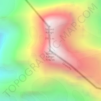
Nome: Mappa topografica Saltoro Kangri, altitudine, rilievo.
Altitudine media: 6’651 m
Altitudine minima: 5’580 m
Altitudine massima: 7’689 m
Fai una donazione
Equipaggiati per la tua prossima avventura:
In qualità di Affiliato Amazon, questo sito riceve una commissione sugli acquisti idonei, senza costi aggiuntivi per l’utente.
Altre mappe topografiche
Clicca su una mappa per visualizzarne la topografia, l'altitudine e il rilievo.