
Mappa topografica Buzău
Mappa interattiva
Clicca sulla mappa per visualizzare l'altitudine.
A proposito di questa mappa
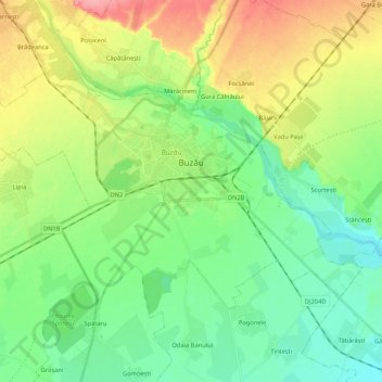
Nome: Mappa topografica Buzău, altitudine, rilievo.
Luogo: Buzău, Romania (45.09161 26.71469 45.18375 26.92587)
Altitudine media: 96 m
Altitudine minima: 66 m
Altitudine massima: 152 m
The city is located in the center of the county, 100 km north-east of Bucharest, in the South-East of Romania, taking up a total area of 81,3 km2, at the outermost curvature of the Subcarpathian foothills, at the crossroads of the three main Romanian historical provinces: Wallachia, Transylvania and Moldavia. It is entirely placed on the right bank of Buzău river, which forms its northern limit. The shape of the city is oblong, longer along the river and shorter across. It reaches altitudes of 101 meters in the North-West, near the foothills, going down to 88 meters on the river bank, while the average altitude of 95 meters is the same as the altitude of Dacia square, in the city center. Thus, Buzău is placed in a flat area, with a height difference of just 10 meters along a 4 kilometer line.
Altre mappe topografiche
Clicca su una mappa per visualizzarne la topografia, l'altitudine e il rilievo.
Bâsca Chiojdului
Bâsca Chiojdului, Chiojdu, Buzău, 127171, Romania
Altitudine media: 732 m
Vadu Oii
Romania > Buzău > Gura Teghii
Vadu Oii, Gura Teghii, Buzău, 127286, Romania
Altitudine media: 819 m