
Fai una donazione
Equipaggiati per la tua prossima avventura:
In qualità di Affiliato Amazon, questo sito riceve una commissione sugli acquisti idonei, senza costi aggiuntivi per l’utente.
Mappa topografica Asind
Clicca sulla mappa per visualizzare l'altitudine.
Fai una donazione
Equipaggiati per la tua prossima avventura:
In qualità di Affiliato Amazon, questo sito riceve una commissione sugli acquisti idonei, senza costi aggiuntivi per l’utente.
Asind
Asind is located at 25°44′N 74°20′E / 25.73°N 74.33°E / 25.73; 74.33. It has an average elevation of 467 metres (1532 feet). Asind is also the name of a Chinese Company located in Hangzhou, Zhejiang Province of China. Mines is Located in Village Shambhugarh, Daultgarh, Roop-pura, Barana, Tehsil Asind, District Bhilwara in Rajasthan of Soda Feldspar Quartz and mica. Tehsil Asind district Bhilwara, Rajasthan. This mine is enriched with one India's unique mineral deposit of Potassium feldspar, Quartz and mica and can meet any quantity at very short span of period. The joint capacity of both of these mines is around 150000 tons of mineral per annum. In Asind there is many mines for Stone which is used to make Houses and buildings in many areas of Rajasthan.
Fai una donazione
Equipaggiati per la tua prossima avventura:
In qualità di Affiliato Amazon, questo sito riceve una commissione sugli acquisti idonei, senza costi aggiuntivi per l’utente.
A proposito di questa mappa
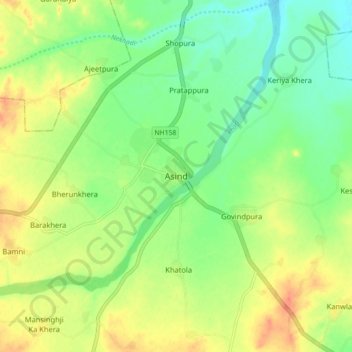
Nome: Mappa topografica Asind, altitudine, rilievo.
Altitudine media: 479 m
Altitudine minima: 459 m
Altitudine massima: 502 m
Fai una donazione
Equipaggiati per la tua prossima avventura:
In qualità di Affiliato Amazon, questo sito riceve una commissione sugli acquisti idonei, senza costi aggiuntivi per l’utente.