
Fai una donazione
Equipaggiati per la tua prossima avventura:
In qualità di Affiliato Amazon, questo sito riceve una commissione sugli acquisti idonei, senza costi aggiuntivi per l’utente.
Mappa topografica Zona Central
Clicca sulla mappa per visualizzare l'altitudine.
Fai una donazione
Equipaggiati per la tua prossima avventura:
In qualità di Affiliato Amazon, questo sito riceve una commissione sugli acquisti idonei, senza costi aggiuntivi per l’utente.
Zona Central
The topography of central Chile includes a coastal range of mountains running parallel to the Andes. Lying between the two mountain ranges is the so-called Central Valley, which contains some of the richest agricultural land in the country, especially in its northern portion. The area just north and south of Santiago is a large producer of fruits, including the grapes from which the best Chilean wines are made. Exports of fresh fruit began to rise dramatically in the mid-1970s because Chilean growers had the advantage of being able to reach markets in the Northern Hemisphere during that part of the world's winter. Most of these exports, such as grapes, apples, and peaches, go by refrigerator ships, but some, such as berries, go by air freight.
Fai una donazione
Equipaggiati per la tua prossima avventura:
In qualità di Affiliato Amazon, questo sito riceve una commissione sugli acquisti idonei, senza costi aggiuntivi per l’utente.
A proposito di questa mappa
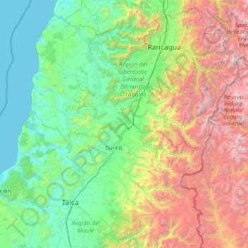
Nome: Mappa topografica Zona Central, altitudine, rilievo.
Altitudine media: 1’121 m
Altitudine minima: 0 m
Altitudine massima: 5’107 m
Fai una donazione
Equipaggiati per la tua prossima avventura:
In qualità di Affiliato Amazon, questo sito riceve una commissione sugli acquisti idonei, senza costi aggiuntivi per l’utente.