
Mappa topografica South Pittsburg
Mappa interattiva
Clicca sulla mappa per visualizzare l'altitudine.
South Pittsburg
South Pittsburg is located at 35°0′30″N 85°42′38″W / 35.00833°N 85.71056°W / 35.00833; -85.71056 (35.008342, -85.710645). The city is situated in the southwestern Sequatchie Valley between the Cumberland Plateau on the west and the Tennessee River (Guntersville Lake) on the east. Two steep ridges— Whitacre Point on the north and Lodge Point on the south— extend outward from the Plateau to "wall in" the main portion of the city on the north, west, and south. The Richard City area lies opposite Lodge Point to the south, and the Battle Creek area lies opposite Whitacre Point to the north. At an elevation of approximately 630 ft (190 m), South Pittsburg is the lowest incorporated city in the East Tennessee Grand Division.
A proposito di questa mappa
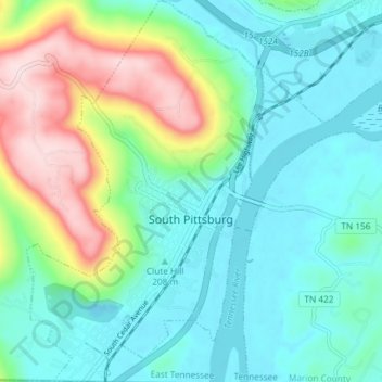
Nome: Mappa topografica South Pittsburg, altitudine, rilievo.
Altitudine media: 272 m
Altitudine minima: 176 m
Altitudine massima: 539 m
Altre mappe topografiche
Clicca su una mappa per visualizzarne la topografia, l'altitudine e il rilievo.