
Fai una donazione
Equipaggiati per la tua prossima avventura:
In qualità di Affiliato Amazon, questo sito riceve una commissione sugli acquisti idonei, senza costi aggiuntivi per l’utente.
Mappa topografica Sestao
Clicca sulla mappa per visualizzare l'altitudine.
Fai una donazione
Equipaggiati per la tua prossima avventura:
In qualità di Affiliato Amazon, questo sito riceve una commissione sugli acquisti idonei, senza costi aggiuntivi per l’utente.
Sestao
The growth of the town of Sestao is limited by the lack of developable land and severely limited by natural and artificial barriers. For this reason, it has reached a highly densified town with a network of small open spaces. Historically, The grew of the population was a consequence of the development of the industry, and not the industry a consequence of the human presence in the area. This defines the DNA of Sestao. It is a settlement that is born exclusively by the implantation of the heavy industry. Consumption and land distribution is based on the industry (now there is more floor dedicated to industrial than residential uses) and these industrial areas are located in the best situations the city. The margin facing the estuary is colonized exclusively for industry, and the least quality areas (up to sixty meters of altitude) is intended to construction of workers' housing.
Fai una donazione
Equipaggiati per la tua prossima avventura:
In qualità di Affiliato Amazon, questo sito riceve una commissione sugli acquisti idonei, senza costi aggiuntivi per l’utente.
A proposito di questa mappa
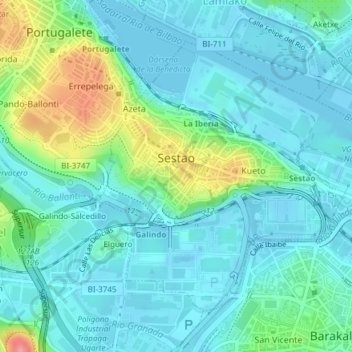
Nome: Mappa topografica Sestao, altitudine, rilievo.
Altitudine media: 21 m
Altitudine minima: -3 m
Altitudine massima: 94 m
Fai una donazione
Equipaggiati per la tua prossima avventura:
In qualità di Affiliato Amazon, questo sito riceve una commissione sugli acquisti idonei, senza costi aggiuntivi per l’utente.
Altre mappe topografiche
Clicca su una mappa per visualizzarne la topografia, l'altitudine e il rilievo.
Hondarribiko hondartza
Spain > Autonomous Community of the Basque Country > Gipuzkoako Bidasoa > Hondarribia
Altitudine media: 31 m
Fai una donazione
Equipaggiati per la tua prossima avventura:
In qualità di Affiliato Amazon, questo sito riceve una commissione sugli acquisti idonei, senza costi aggiuntivi per l’utente.
Gebara
Spain > Autonomous Community of the Basque Country > Arabako lautada/Llanada Alavesa
Altitudine media: 574 m
Fai una donazione
Equipaggiati per la tua prossima avventura:
In qualità di Affiliato Amazon, questo sito riceve una commissione sugli acquisti idonei, senza costi aggiuntivi per l’utente.
Gorbeia
Spain > Autonomous Community of the Basque Country > Gorbeialdea > Zeanuri
Altitudine media: 1’189 m
Karakate
Spain > Autonomous Community of the Basque Country > Debabarrena > Soraluze
Altitudine media: 366 m
Fai una donazione
Equipaggiati per la tua prossima avventura:
In qualità di Affiliato Amazon, questo sito riceve una commissione sugli acquisti idonei, senza costi aggiuntivi per l’utente.
Santa Barbara
Spain > Autonomous Community of the Basque Country > Hernani > Sorgintxulo
Altitudine media: 68 m
Bujal
Spain > Autonomous Community of the Basque Country > Añanako kuadrilla > Berantevilla
Altitudine media: 535 m
Araneta
Spain > Autonomous Community of the Basque Country > Gasteizko kuadrilla/Cuadrilla de Vitoria > Vitoria-Gasteiz > Bolívar
Altitudine media: 625 m
Soil
Spain > Autonomous Community of the Basque Country > Montaña Alavesa/Arabako Mendialdea
Altitudine media: 898 m
Fai una donazione
Equipaggiati per la tua prossima avventura:
In qualità di Affiliato Amazon, questo sito riceve una commissione sugli acquisti idonei, senza costi aggiuntivi per l’utente.
Makola
Spain > Autonomous Community of the Basque Country > Urola-Kosta > Azkoitia
Altitudine media: 515 m
Fuente Oneri
Spain > Autonomous Community of the Basque Country > Arabako lautada/Llanada Alavesa > Agurain/Salvatierra
Altitudine media: 681 m
Iruka
Spain > Autonomous Community of the Basque Country > Debabarrena > Eibar
Altitudine media: 425 m
Fai una donazione
Equipaggiati per la tua prossima avventura:
In qualità di Affiliato Amazon, questo sito riceve una commissione sugli acquisti idonei, senza costi aggiuntivi per l’utente.
Torrea
Spain > Autonomous Community of the Basque Country > Debabarrena > Eibar
Altitudine media: 398 m
Flysch
Spain > Autonomous Community of the Basque Country > Urola-Kosta > Zumaia
Altitudine media: 27 m
Barinatxe - La Salvaje
Spain > Autonomous Community of the Basque Country > Sopela
Altitudine media: 26 m
Lore-Toki
Spain > Autonomous Community of the Basque Country > Arabako Errioxa/Rioja Alavesa > Labastida/Bastida
Altitudine media: 499 m
Fai una donazione
Equipaggiati per la tua prossima avventura:
In qualità di Affiliato Amazon, questo sito riceve una commissione sugli acquisti idonei, senza costi aggiuntivi per l’utente.
Trevilla
Spain > Autonomous Community of the Basque Country > Karrantza Harana/Valle de Carranza > Concha
Altitudine media: 333 m
Fai una donazione
Equipaggiati per la tua prossima avventura:
In qualità di Affiliato Amazon, questo sito riceve una commissione sugli acquisti idonei, senza costi aggiuntivi per l’utente.
Floreaga
Spain > Autonomous Community of the Basque Country > Urola-Kosta > Azkoitia
Altitudine media: 266 m
Monterredondo
Spain > Autonomous Community of the Basque Country > Añanako kuadrilla/Cuadrilla de Añana
Altitudine media: 875 m
Fai una donazione
Equipaggiati per la tua prossima avventura:
In qualità di Affiliato Amazon, questo sito riceve una commissione sugli acquisti idonei, senza costi aggiuntivi per l’utente.
Plaza de Larrazábal
Spain > Autonomous Community of the Basque Country > Bilbao
Altitudine media: 101 m
Fai una donazione
Equipaggiati per la tua prossima avventura:
In qualità di Affiliato Amazon, questo sito riceve una commissione sugli acquisti idonei, senza costi aggiuntivi per l’utente.
Gautegiz Arteaga
Spain > Autonomous Community of the Basque Country > Gautegiz Arteaga > Gautegiz Arteaga
Altitudine media: 104 m
Zaldibar
Spain > Autonomous Community of the Basque Country > Zaldibar > Zaldibar
Altitudine media: 305 m
Soil
Spain > Autonomous Community of the Basque Country > Montaña Alavesa/Arabako Mendialdea
Altitudine media: 898 m