
Mappa topografica Mount Sonder
Clicca sulla mappa per visualizzare l'altitudine.
A proposito di questa mappa
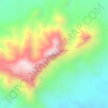
Nome: Mappa topografica Mount Sonder, altitudine, rilievo.
Altitudine media: 1’005 m
Altitudine minima: 744 m
Altitudine massima: 1’356 m
Altre mappe topografiche
Clicca su una mappa per visualizzarne la topografia, l'altitudine e il rilievo.
Sydney
Sydney's topography is characterized by a diverse landscape that seamlessly blends coastal features with inland plateaus. The city is divided into two primary regions: the relatively flat Cumberland Plain to the south and west of Sydney Harbour, and the elevated Hornsby Plateau to the north. The Cumberland…
Altitudine media: 53 m
Victoria
Victoria, Australia, exhibits a remarkably varied topography shaped by the Great Dividing Range, which forms a west-to-east spine across the state. In the northeast, the Victorian Alps rise to the state’s highest point, Mount Bogong at 1,986 meters, amid deep valleys and snow-capped ridges, while westward,…
Altitudine media: 179 m
City of Melbourne
Melbourne's topography is characterized by a diverse landscape that transitions from flat coastal plains to rolling hills and mountainous regions. The city is situated at the northern end of Port Phillip Bay, where the terrain is predominantly flat, facilitating urban development. As one moves eastward, the…
Altitudine media: 18 m
New South Wales
New South Wales (NSW), located on Australia's eastern seaboard, boasts a diverse topography that significantly influences its landscapes and ecosystems. The state's eastern edge is dominated by a narrow coastal plain, featuring regions such as the Illawarra and Shoalhaven near Nowra, characterized by rolling…
Altitudine media: 154 m
Tasmania
The most mountainous region is the Central Highlands area, which covers most of the central western parts of the state. The Midlands located in the central east, is fairly flat, and is predominantly used for agriculture, although farming activity is scattered throughout the state. Tasmania's tallest mountain…
Altitudine media: 220 m
Western Australia
Because the only mountain-building since then has been of the Stirling Range with the rifting from Antarctica, the land is extremely eroded and ancient, with no part of the state above 1,245 metres (4,085 ft) AHD (at Mount Meharry in the Hamersley Range of the Pilbara region). Most of the state is a low…
Altitudine media: 194 m
Queensland
Queensland's topography is characterized by a diverse landscape that includes coastal plains, mountain ranges, plateaus, and expansive inland areas. The Great Dividing Range runs parallel to the state's eastern coast, forming a series of mountain ranges, plateaus, and upland areas. This range influences the…
Altitudine media: 122 m
Melbourne
Melbourne is also prone to isolated convective showers forming when a cold pool crosses the state, especially if there is considerable daytime heating. These showers are often heavy and can include hail, squalls, and significant drops in temperature, but they often pass through very quickly with a rapid…
Altitudine media: 185 m
New South Wales
New South Wales (NSW), located on Australia's eastern seaboard, boasts a diverse topography that significantly influences its landscapes and ecosystems. The state's eastern edge is dominated by a narrow coastal plain, featuring regions such as the Illawarra and Shoalhaven near Nowra, characterized by rolling…
Altitudine media: 154 m
Melbourne
Melbourne is also prone to isolated convective showers forming when a cold pool crosses the state, especially if there is considerable daytime heating. These showers are often heavy and can include hail, squalls, and significant drops in temperature, but they often pass through very quickly with a rapid…
Altitudine media: 185 m
Great Dividing Range
The Great Dividing Range, also known as the East Australian Cordillera or the Eastern Highlands, is a cordillera system in eastern Australia consisting of an expansive collection of mountain ranges, plateaus and rolling hills, that runs roughly parallel to the east coast of Australia and forms the…
Altitudine media: 117 m
Yass
Yass is located 280 km south-west of Sydney, on the Hume Highway. The Yass River, which is a tributary of the Murrumbidgee River, flows through the town. Yass is 59 km from Canberra; lying at an elevation of 505 m AMSL.
Altitudine media: 533 m
Penrith
Australia > New South Wales > Sydney > Penrith
Penrith is a city in New South Wales, Australia, located in Greater Western Sydney, 55 kilometres (31 mi) west of the Sydney central business district on the banks of the Nepean River, on the outskirts of the Cumberland Plain. Its elevation is 32 metres (105 ft).
Altitudine media: 34 m
City of Brisbane
Brisbane's topography is characterized by a series of hills and ranges that define its landscape. The city is situated on a low-lying floodplain, with the Brisbane River meandering through its heart, creating a winding course with many steep curves from the southwest to its mouth at Moreton Bay in the east.…
Altitudine media: 71 m
Warwick
Warwick experiences an altitude-influenced humid subtropical climate (Köppen: Cfa), with hot summers and mild, relatively dry winters with cold nights. Annual precipitation averages 662.4 millimetres (26.08 in), with a summer maximum. The town is slightly cooler and less humid than the proximate southeast…
Altitudine media: 474 m
Brisbane River
The RAAF also perform a practice session in the days preceding the event, serving as an opportunity to both practice beforehand and also promote Riverfire. One of the most popular RAAF aircraft to perform at Riverfire was the F-111 which was known for performing a 'dump-and-burn' above the city. The final…
Altitudine media: 235 m
Camberwell
Australia > Victoria > Melbourne
The Prospect Hill Road Precinct area is adjacent to the railway station and is the oldest part of the suburb. The original subdivision was relatively generous blocks, which were quickly filled with fine Victorian and Edwardian houses. Due to its hilly topography, many east–west streets in the Prospect Hill…
Altitudine media: 66 m
Bribie Island
Australia > Queensland > Brisbane
Bribie Island, located in Queensland, Australia, is a low-lying, elongated landmass stretching approximately 34 kilometers (21 miles) in length and up to 8 kilometers (5 miles) at its widest point. Composed predominantly of coastal sand plains, the island features two large, low-lying dunes extending…
Altitudine media: 6 m
Great Sandy Strait
There are numerous named and unnamed islands in the strait. The named island are from north to south: Big Woody Island, Round Island, Little Woody Island, Picnic Island, Duck Island, Walsh Island, Turkey Island, Bookar Island, Thomas Island, Slain Island, Tooth Island, Round Bush Island, New Island, Garden…
Altitudine media: 28 m
Barrington Tops National Park
The climate varies from temperate on the lower altitudes to subalpine at highest elevations. A record low of −17 °C (1 °F) has been registered at 1,500 m (4,900 ft) above mean sea level. Rainfalls fluctuate between 750 millimetres (30 in) in the northwest to more than 2,000 mm (79 in) in the southeast.
Altitudine media: 736 m