
Fai una donazione
Equipaggiati per la tua prossima avventura:
In qualità di Affiliato Amazon, questo sito riceve una commissione sugli acquisti idonei, senza costi aggiuntivi per l’utente.
Mappa topografica Veracruz City
Clicca sulla mappa per visualizzare l'altitudine.
Fai una donazione
Equipaggiati per la tua prossima avventura:
In qualità di Affiliato Amazon, questo sito riceve una commissione sugli acquisti idonei, senza costi aggiuntivi per l’utente.
Veracruz City
As the municipal seat, the city of Veracruz is the governing authority for 128 other named localities during the 2010 census, forming a municipality with a territory of 241 km2 (93 sq mi). The population of the municipality is 552,156 inhabitants, of whom 428,323 or approximately 77.6% live in municipality's portion of the city proper. The municipality is bordered by the municipalities of La Antigua, Boca del Río, Manlio Fabio Altamirano, Medellín, and Paso de Ovejas, with the Gulf of Mexico to the northeast, and has an average altitude of ten meters above sea level. The area is flat with little in the way of elevations and is crossed by the Medio, Grande and Tonayán Rivers. There are also beaches here such as the Sacrificios and Verde. Its climate is tropical with an average temperature of 25.3 °C (77.5 °F). Vegetation is mostly of the rainforest type, with many trees losing leaves during the winter dry season. Fauna mostly consists of birds, small mammals and insects.
Fai una donazione
Equipaggiati per la tua prossima avventura:
In qualità di Affiliato Amazon, questo sito riceve una commissione sugli acquisti idonei, senza costi aggiuntivi per l’utente.
A proposito di questa mappa
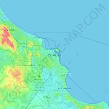
Nome: Mappa topografica Veracruz City, altitudine, rilievo.
Altitudine media: 10 m
Altitudine minima: -2 m
Altitudine massima: 116 m
Fai una donazione
Equipaggiati per la tua prossima avventura:
In qualità di Affiliato Amazon, questo sito riceve una commissione sugli acquisti idonei, senza costi aggiuntivi per l’utente.