
Fai una donazione
Equipaggiati per la tua prossima avventura:
In qualità di Affiliato Amazon, questo sito riceve una commissione sugli acquisti idonei, senza costi aggiuntivi per l’utente.
Mappa topografica Red Wing
Clicca sulla mappa per visualizzare l'altitudine.
Fai una donazione
Equipaggiati per la tua prossima avventura:
In qualità di Affiliato Amazon, questo sito riceve una commissione sugli acquisti idonei, senza costi aggiuntivi per l’utente.
Red Wing
According to the United States Census Bureau, the city has an area of 41.19 square miles (106.68 km2), of which 34.60 square miles (89.61 km2) is land and 6.59 square miles (17.07 km2) is water. The city is at the northern edge of the Driftless Area of karst topography.
Fai una donazione
Equipaggiati per la tua prossima avventura:
In qualità di Affiliato Amazon, questo sito riceve una commissione sugli acquisti idonei, senza costi aggiuntivi per l’utente.
A proposito di questa mappa
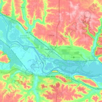
Nome: Mappa topografica Red Wing, altitudine, rilievo.
Luogo: Red Wing, Goodhue County, Minnesota, 55066, United States (44.52796 -92.67277 44.66966 -92.46723)
Altitudine media: 263 m
Altitudine minima: 199 m
Altitudine massima: 353 m
Fai una donazione
Equipaggiati per la tua prossima avventura:
In qualità di Affiliato Amazon, questo sito riceve una commissione sugli acquisti idonei, senza costi aggiuntivi per l’utente.
Altre mappe topografiche
Clicca su una mappa per visualizzarne la topografia, l'altitudine e il rilievo.
Cannon Falls
United States > Minnesota > Goodhue County > Cannon Falls > Cannon Falls
Altitudine media: 268 m
Fai una donazione
Equipaggiati per la tua prossima avventura:
In qualità di Affiliato Amazon, questo sito riceve una commissione sugli acquisti idonei, senza costi aggiuntivi per l’utente.