
Fai una donazione
Equipaggiati per la tua prossima avventura:
In qualità di Affiliato Amazon, questo sito riceve una commissione sugli acquisti idonei, senza costi aggiuntivi per l’utente.
Mappa topografica Sircilla
Clicca sulla mappa per visualizzare l'altitudine.
Fai una donazione
Equipaggiati per la tua prossima avventura:
In qualità di Affiliato Amazon, questo sito riceve una commissione sugli acquisti idonei, senza costi aggiuntivi per l’utente.
Sircilla
The town is located at 18°23′N 78°50′E / 18.38°N 78.83°E / 18.38; 78.83. It has an average elevation of 322 metres (1056 feet). By road, it is located 120 km north of Secunderabad, 40 km west of Karimnagar, 30 km north of Siddipet and 56 km east of Kamareddy. It is 10 km away from the famous Vemulawada temple.
Fai una donazione
Equipaggiati per la tua prossima avventura:
In qualità di Affiliato Amazon, questo sito riceve una commissione sugli acquisti idonei, senza costi aggiuntivi per l’utente.
A proposito di questa mappa
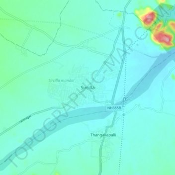
Nome: Mappa topografica Sircilla, altitudine, rilievo.
Altitudine media: 338 m
Altitudine minima: 312 m
Altitudine massima: 511 m
Fai una donazione
Equipaggiati per la tua prossima avventura:
In qualità di Affiliato Amazon, questo sito riceve una commissione sugli acquisti idonei, senza costi aggiuntivi per l’utente.