
Fai una donazione
Equipaggiati per la tua prossima avventura:
In qualità di Affiliato Amazon, questo sito riceve una commissione sugli acquisti idonei, senza costi aggiuntivi per l’utente.
Mappa topografica Ol Donyo Sabuk
Clicca sulla mappa per visualizzare l'altitudine.
Fai una donazione
Equipaggiati per la tua prossima avventura:
In qualità di Affiliato Amazon, questo sito riceve una commissione sugli acquisti idonei, senza costi aggiuntivi per l’utente.
Ol Donyo Sabuk
The Fourteen Falls area is protected and equipped with a picnic site. as it has historical and religious importance both to the residents and Asian immigrants. The Asians use the site for recreation and spiritual rites, disposing of cremated ash in the river in the belief that it will go all the way to India through the Indian Ocean, hence acting as a shrine. Others come for recreation, retaining the Happy Valley theme that was first introduced by Lord McMillan. Like Lord McMillan, the adjacent community, some of whom are descendants of the people the adventurer brought here, still farm the land. Fourteen Falls is located just a little bit away from Thika town. The falls are geographically situated at an altitude of approximately 1400 metres above sea level.
Fai una donazione
Equipaggiati per la tua prossima avventura:
In qualità di Affiliato Amazon, questo sito riceve una commissione sugli acquisti idonei, senza costi aggiuntivi per l’utente.
A proposito di questa mappa
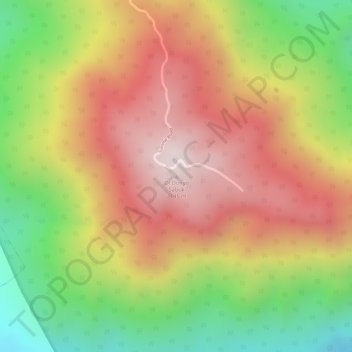
Nome: Mappa topografica Ol Donyo Sabuk, altitudine, rilievo.
Altitudine media: 1’866 m
Altitudine minima: 1’513 m
Altitudine massima: 2’145 m
Fai una donazione
Equipaggiati per la tua prossima avventura:
In qualità di Affiliato Amazon, questo sito riceve una commissione sugli acquisti idonei, senza costi aggiuntivi per l’utente.