
Mappa topografica Weets Hill
Clicca sulla mappa per visualizzare l'altitudine.
A proposito di questa mappa
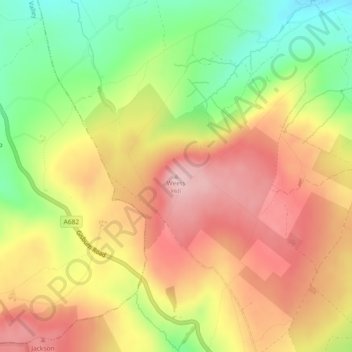
Nome: Mappa topografica Weets Hill, altitudine, rilievo.
Altitudine media: 300 m
Altitudine minima: 187 m
Altitudine massima: 396 m
Altre mappe topografiche
Clicca su una mappa per visualizzarne la topografia, l'altitudine e il rilievo.
Colne Water
United Kingdom > England > Lancashire > Borough of Pendle > Laneshaw Bridge
Altitudine media: 202 m
Colne
United Kingdom > England > Lancashire > Borough of Pendle
Pendle Leisure Trust runs the Pendle Leisure Centre next to the railway station. The facility has two swimming pools, a fitness centre and gymnasium, sauna and sports hall. In summer 2013, the outdoor all-weather pitch was replaced by Urban Altitude. This outdoor aerial assault course is the first of its kind…
Altitudine media: 197 m
Laneshaw Bridge
United Kingdom > England > Lancashire > Borough of Pendle > Laneshaw Bridge
Altitudine media: 269 m
Barrowford
United Kingdom > England > Lancashire > Borough of Pendle > Barrowford
Altitudine media: 161 m
Barnoldswick
United Kingdom > England > Lancashire > Borough of Pendle > Salterforth
Altitudine media: 175 m
Colne
United Kingdom > England > Lancashire > Borough of Pendle
Pendle Leisure Trust runs the Pendle Leisure Centre next to the railway station. The facility has two swimming pools, a fitness centre and gymnasium, sauna and sports hall. In summer 2013, the outdoor all-weather pitch was replaced by Urban Altitude. This outdoor aerial assault course is the first of its kind…
Altitudine media: 197 m
Barnoldswick
United Kingdom > England > Lancashire > Borough of Pendle > Salterforth
Altitudine media: 175 m