
Mappa topografica Village of Walden
Mappa interattiva
Clicca sulla mappa per visualizzare l'altitudine.
A proposito di questa mappa
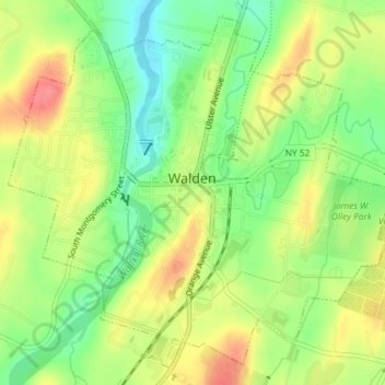
Nome: Mappa topografica Village of Walden, altitudine, rilievo.
Altitudine media: 114 m
Altitudine minima: 80 m
Altitudine massima: 149 m
The Wallkill passes through a small gorge between the two dams and loses approximately 60 feet (18 m) of elevation in the process. The surrounding topography in the village is, correspondingly, gentle rolling hills of this section of the Great Appalachian Valley between the higher rises of the Shawangunk Ridge, visible to the west from some sections of the village, and the Hudson Highlands to the southwest. The highest elevation is roughly 520 feet (160 m) above sea level along Overlook Road at the village's western boundary; the lowest is 260 feet (79 m) along the Wallkill at the northern village line.
Altre mappe topografiche
Clicca su una mappa per visualizzarne la topografia, l'altitudine e il rilievo.
Cuddebackville
United States > New York > Orange County
Cuddebackville, Town of Deerpark, Orange County, New York, 12729, United States
Altitudine media: 216 m
Town of Monroe
United States > New York > Orange County
Town of Monroe, Orange County, New York, United States
Altitudine media: 229 m
Hawks Nest
United States > New York > Orange County
Hawks Nest, Town of Deerpark, Orange County, New York, 18340, United States
Altitudine media: 230 m
Village of Monroe
United States > New York > Orange County
Village of Monroe, Town of Monroe, Orange County, New York, 10950, United States
Altitudine media: 217 m
Village of Tuxedo Park
United States > New York > Orange County > Town of Tuxedo
Village of Tuxedo Park, Town of Tuxedo, Orange County, New York, 10987, United States
Altitudine media: 230 m