
Mappa topografica Taunton
Mappa interattiva
Clicca sulla mappa per visualizzare l'altitudine.
A proposito di questa mappa
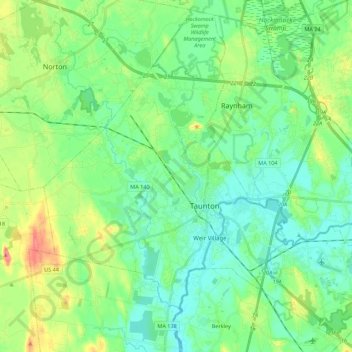
Nome: Mappa topografica Taunton, altitudine, rilievo.
Luogo: Taunton, Bristol County, Massachusetts, United States (41.83849 -71.19390 41.99318 -70.97372)
Altitudine media: 22 m
Altitudine minima: 0 m
Altitudine massima: 78 m
Taunton has one major river, the Taunton River, along with its tributaries including the Mill River and the Three Mile River. The highest point in the city is near its southwest corner, with an elevation of 207 feet (63 m) above sea level. Prospect Hill, rising over Lake Sabbatia north of the downtown, has an elevation of 197 feet (60 m).