
Fai una donazione
Equipaggiati per la tua prossima avventura:
In qualità di Affiliato Amazon, questo sito riceve una commissione sugli acquisti idonei, senza costi aggiuntivi per l’utente.
Mappa topografica Great Houghton
Clicca sulla mappa per visualizzare l'altitudine.
Fai una donazione
Equipaggiati per la tua prossima avventura:
In qualità di Affiliato Amazon, questo sito riceve una commissione sugli acquisti idonei, senza costi aggiuntivi per l’utente.
Great Houghton
Great Houghton is a village and civil parish in the Metropolitan Borough of Barnsley in South Yorkshire, England), on the border with West Yorkshire. It lies to the west of Thurnscoe, on the B6411 road, and is located at approximately 53° 33' 20" north, 1° 21' west, at an elevation of around 60 m above sea level. At the 2001 census it had a population of 2,261, increasing to 2,475 at the 2011 census.
Fai una donazione
Equipaggiati per la tua prossima avventura:
In qualità di Affiliato Amazon, questo sito riceve una commissione sugli acquisti idonei, senza costi aggiuntivi per l’utente.
A proposito di questa mappa
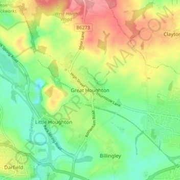
Nome: Mappa topografica Great Houghton, altitudine, rilievo.
Altitudine media: 54 m
Altitudine minima: 13 m
Altitudine massima: 112 m
Fai una donazione
Equipaggiati per la tua prossima avventura:
In qualità di Affiliato Amazon, questo sito riceve una commissione sugli acquisti idonei, senza costi aggiuntivi per l’utente.