
Mappa topografica Blakeney
Mappa interattiva
Clicca sulla mappa per visualizzare l'altitudine.
A proposito di questa mappa
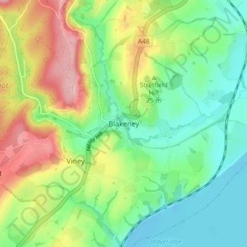
Nome: Mappa topografica Blakeney, altitudine, rilievo.
Altitudine media: 58 m
Altitudine minima: -3 m
Altitudine massima: 159 m
Altre mappe topografiche
Clicca su una mappa per visualizzarne la topografia, l'altitudine e il rilievo.
Brockweir
United Kingdom > England > Gloucestershire > Forest of Dean
Brockweir, Forest of Dean, Gloucestershire, England, NP16 7NG, United Kingdom
Altitudine media: 145 m
Lydney
United Kingdom > England > Gloucestershire > Forest of Dean
Lydney, Forest of Dean, Gloucestershire, South West England, England, United Kingdom
Altitudine media: 45 m
Broadwell
United Kingdom > England > Gloucestershire > Forest of Dean > Broadwell
Broadwell, Forest of Dean, Gloucestershire, South West England, England, GL16 7BH, United Kingdom
Altitudine media: 184 m