
Mappa topografica Napanoch
Mappa interattiva
Clicca sulla mappa per visualizzare l'altitudine.
A proposito di questa mappa
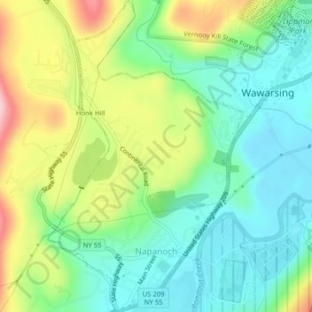
Nome: Mappa topografica Napanoch, altitudine, rilievo.
Altitudine media: 146 m
Altitudine minima: 77 m
Altitudine massima: 275 m
Altre mappe topografiche
Clicca su una mappa per visualizzarne la topografia, l'altitudine e il rilievo.
Sam's Point Overlook
United States > New York > Ulster County > Town of Wawarsing > Village of Ellenville
Sam's Point Overlook, Loop Road, Village of Ellenville, Town of Wawarsing, Ulster County, New York, 12420, United States
Altitudine media: 542 m
Bear Hill Preserve (Cragsmoor Free Library)
United States > New York > Ulster County > Town of Wawarsing > Cragsmoor
Bear Hill Preserve (Cragsmoor Free Library), Route 52, Cragsmoor, Town of Wawarsing, Town of Shawangunk, Ulster County, New York, 12428, United States
Altitudine media: 414 m
Sholam
United States > New York > Ulster County > Town of Wawarsing
Sholam, Town of Wawarsing, Ulster County, New York, 12458, United States
Altitudine media: 383 m
Village of Ellenville
United States > New York > Ulster County > Town of Wawarsing
Village of Ellenville, Town of Wawarsing, Ulster County, New York, United States
Altitudine media: 325 m
Greenfield Park
United States > New York > Ulster County > Town of Wawarsing
Greenfield Park, Town of Wawarsing, Ulster County, New York, 12435, United States
Altitudine media: 331 m
Kerhonkson
United States > New York > Ulster County > Town of Wawarsing
Kerhonkson, Town of Wawarsing, Ulster County, New York, United States
Altitudine media: 167 m