
Mappa topografica Chilliwack
Clicca sulla mappa per visualizzare l'altitudine.
A proposito di questa mappa
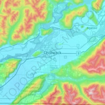
Nome: Mappa topografica Chilliwack, altitudine, rilievo.
Altitudine media: 381 m
Altitudine minima: -1 m
Altitudine massima: 1’986 m
Altre mappe topografiche
Clicca su una mappa per visualizzarne la topografia, l'altitudine e il rilievo.
Mission
Canada > British Columbia > Fraser Valley Regional District
The western part of the district, the Stave Valley, is largely rural and forested but its watercourse is home to what was the largest hydroelectric project in British Columbia until the Bridge River Power Project opened in 1961. It was built by the British Columbia Electric Railway (BCER) to provide power to…
Altitudine media: 345 m
Glacier Lake
Canada > British Columbia > Fraser Valley Regional District > Area C (Sasquatch Country)
Altitudine media: 614 m
Harrison Hot Springs
Canada > British Columbia > Fraser Valley Regional District
Altitudine media: 203 m
Area E (Chilliwack River Valley)
Canada > British Columbia > Fraser Valley Regional District
Altitudine media: 1’032 m
Harrison River
Canada > British Columbia > Fraser Valley Regional District > Kent > Harrison Mills
Altitudine media: 45 m
Sumas River
Canada > British Columbia > Fraser Valley Regional District > Abbotsford
Altitudine media: 167 m
Harrison Lake
Canada > British Columbia > Fraser Valley Regional District > Area C (Sasquatch Country)
Altitudine media: 815 m
Stave Lake
Canada > British Columbia > Fraser Valley Regional District > Mission
Altitudine media: 573 m
Chehalis Lake
Canada > British Columbia > Fraser Valley Regional District > Area C (Sasquatch Country)
Altitudine media: 735 m
Chilliwack Lake
Canada > British Columbia > Fraser Valley Regional District > Area E (Chilliwack River Valley)
Altitudine media: 1’152 m
Sloquet Creek
Canada > British Columbia > Fraser Valley Regional District > Area C (Sasquatch Country)
Altitudine media: 255 m
Campbell Lake
Canada > British Columbia > Fraser Valley Regional District > Kent
Altitudine media: 528 m
Area F (McConnell Creek/Hatzic Prairie)
Canada > British Columbia > Fraser Valley Regional District
Altitudine media: 832 m
Falls Lake
Canada > British Columbia > Fraser Valley Regional District > Area B (South Fraser Canyon/Sunshine Valley)
Altitudine media: 1’512 m
Jones Lake
Canada > British Columbia > Fraser Valley Regional District > Area D (Popkum/Bridal Falls/Wahleach)
Altitudine media: 956 m
Stoney Creek Park
Canada > British Columbia > Fraser Valley Regional District > Abbotsford
Altitudine media: 40 m
Area B (South Fraser Canyon/Sunshine Valley)
Canada > British Columbia > Fraser Valley Regional District
Altitudine media: 1’174 m
Area A (Boston Bar/North Bend/Canyon Alpine)
Canada > British Columbia > Fraser Valley Regional District
Altitudine media: 1’260 m
Area H (Cultus Lake/Columbia Valley)
Canada > British Columbia > Fraser Valley Regional District
Altitudine media: 566 m
Sumas Prairie
Canada > British Columbia > Fraser Valley Regional District > Abbotsford
Altitudine media: 159 m
Cultus Lake
Canada > British Columbia > Fraser Valley Regional District > Area H (Cultus Lake/Columbia Valley) > Cultus Lake
Altitudine media: 191 m
Serpentine Lake
Canada > British Columbia > Fraser Valley Regional District > Area B (South Fraser Canyon/Sunshine Valley)
Altitudine media: 960 m
Isabel Lake
Canada > British Columbia > Fraser Valley Regional District > Area F (McConnell Creek/Hatzic Prairie)
Altitudine media: 687 m
Vedder River
Canada > British Columbia > Fraser Valley Regional District > Chilliwack
Altitudine media: 110 m
Area C (Sasquatch Country)
Canada > British Columbia > Fraser Valley Regional District
Altitudine media: 988 m
Chehalis River
Canada > British Columbia > Fraser Valley Regional District > Area C (Sasquatch Country)
Altitudine media: 424 m
Misty Icefield
Canada > British Columbia > Fraser Valley Regional District > Area F (McConnell Creek/Hatzic Prairie)
Altitudine media: 1’800 m
Mamquam Icefield
Canada > British Columbia > Fraser Valley Regional District > Area F (McConnell Creek/Hatzic Prairie)
Altitudine media: 1’925 m
Hope Slide
Canada > British Columbia > Fraser Valley Regional District > Area B (South Fraser Canyon/Sunshine Valley)
Altitudine media: 1’160 m
Mission
Canada > British Columbia > Fraser Valley Regional District
The western part of the district, the Stave Valley, is largely rural and forested but its watercourse is home to what was the largest hydroelectric project in British Columbia until the Bridge River Power Project opened in 1961. It was built by the British Columbia Electric Railway (BCER) to provide power to…
Altitudine media: 345 m
Sumas Prairie
Canada > British Columbia > Fraser Valley Regional District > Abbotsford
Altitudine media: 159 m
Area D (Popkum/Bridal Falls/Wahleach)
Canada > British Columbia > Fraser Valley Regional District
Altitudine media: 948 m
Mission
Canada > British Columbia > Fraser Valley Regional District
The western part of the district, the Stave Valley, is largely rural and forested but its watercourse is home to what was the largest hydroelectric project in British Columbia until the Bridge River Power Project opened in 1961. It was built by the British Columbia Electric Railway (BCER) to provide power to…
Altitudine media: 345 m
Turner Glacier
Canada > British Columbia > Fraser Valley Regional District > Area C (Sasquatch Country)
Altitudine media: 2’183 m
Ryder Lake
Canada > British Columbia > Fraser Valley Regional District > Chilliwack
Altitudine media: 255 m
Harrison-Chehalis Wildlife Management Area
Canada > British Columbia > Fraser Valley Regional District > Area C (Sasquatch Country) > Harrison Mills
Altitudine media: 187 m
Misty Icefield
Canada > British Columbia > Fraser Valley Regional District > Area F (McConnell Creek/Hatzic Prairie)
Altitudine media: 1’800 m
Area D (Popkum/Bridal Falls/Wahleach)
Canada > British Columbia > Fraser Valley Regional District
Altitudine media: 948 m
Area B (South Fraser Canyon/Sunshine Valley)
Canada > British Columbia > Fraser Valley Regional District
Altitudine media: 1’174 m
Area D (Popkum/Bridal Falls/Wahleach)
Canada > British Columbia > Fraser Valley Regional District
Altitudine media: 948 m
Mission
Canada > British Columbia > Fraser Valley Regional District
The western part of the district, the Stave Valley, is largely rural and forested but its watercourse is home to what was the largest hydroelectric project in British Columbia until the Bridge River Power Project opened in 1961. It was built by the British Columbia Electric Railway (BCER) to provide power to…
Altitudine media: 345 m
Harrison Hot Springs
Canada > British Columbia > Fraser Valley Regional District
Altitudine media: 206 m
Area B (South Fraser Canyon/Sunshine Valley)
Canada > British Columbia > Fraser Valley Regional District
Altitudine media: 1’174 m