
Mappa topografica Saint Joseph
Mappa interattiva
Clicca sulla mappa per visualizzare l'altitudine.
A proposito di questa mappa
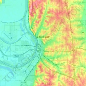
Nome: Mappa topografica Saint Joseph, altitudine, rilievo.
Luogo: Saint Joseph, Buchanan County, Missouri, United States (39.69722 -94.89903 39.82126 -94.74334)
Altitudine media: 277 m
Altitudine minima: 241 m
Altitudine massima: 343 m
Under the Köppen climate classification, St. Joseph has a humid subtropical climate (Cfa) bordering on a humid continental climate (Dfa), although under United States isotherms of 32 °F (0 °C) the station is firmly continental. The monthly weather averages listed below are taken from National Weather Service 1981-2010 Normals recorded at Rosecrans Airport. Because of the Airport's location near the Missouri River and at a low elevation, official overnight lows during wintertime especially are often several degrees colder than at other places within the city.[15] Snowfall is not recorded at the St Joseph weather station although surrounding reporting stations typically receive 12-20 inches of snowfall annually.[16][17][18]
Altre mappe topografiche
Clicca su una mappa per visualizzarne la topografia, l'altitudine e il rilievo.
Buchanan County
United States > Missouri > Buchanan County
Buchanan County, Missouri, United States
Altitudine media: 288 m