
Mappa topografica Saskatoon
Clicca sulla mappa per visualizzare l'altitudine.
Saskatoon
Saskatoon lies on a long belt of rich, potassic chernozem in middle-southern Saskatchewan and is found in the aspen parkland biome. The lack of surrounding mountainous topography gives the city a relatively flat grid, though the city does sprawl over a few hills and into a few valleys. The lowest point in the city is the river, while the highest point is disputed between the suburb of Sutherland in the east side and the Silverwood-River Heights areas in the city's north end. Saskatoon, on a cross-section from west to east, has a general decline in elevation above sea level heading towards the river, and on the east bank of the river, the terrain is mostly level until outside the city, where it begins to decrease in elevation again.
A proposito di questa mappa
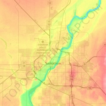
Nome: Mappa topografica Saskatoon, altitudine, rilievo.
Luogo: Saskatoon, Saskatchewan, Canada (52.06980 -106.82497 52.23114 -106.50370)
Altitudine media: 504 m
Altitudine minima: 462 m
Altitudine massima: 535 m
Altre mappe topografiche
Clicca su una mappa per visualizzarne la topografia, l'altitudine e il rilievo.
McClean Lake
Canada > Saskatchewan > Division No. 18 > Unorganized Division No. 18
Altitudine media: 440 m
La Loche
Canada > Saskatchewan > Northern Saskatchewan Administration District > La Loche
Altitudine media: 447 m
Pelican Narrows
Canada > Saskatchewan > Northern Saskatchewan Administration District > Pelican Narrows
Altitudine media: 321 m