
Fai una donazione
Equipaggiati per la tua prossima avventura:
In qualità di Affiliato Amazon, questo sito riceve una commissione sugli acquisti idonei, senza costi aggiuntivi per l’utente.
Mappa topografica Chaparral
Clicca sulla mappa per visualizzare l'altitudine.
Fai una donazione
Equipaggiati per la tua prossima avventura:
In qualità di Affiliato Amazon, questo sito riceve una commissione sugli acquisti idonei, senza costi aggiuntivi per l’utente.
A proposito di questa mappa
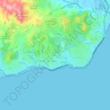
Nome: Mappa topografica Chaparral, altitudine, rilievo.
Altitudine media: 29 m
Altitudine minima: -1 m
Altitudine massima: 158 m
Fai una donazione
Equipaggiati per la tua prossima avventura:
In qualità di Affiliato Amazon, questo sito riceve una commissione sugli acquisti idonei, senza costi aggiuntivi per l’utente.
Altre mappe topografiche
Clicca su una mappa per visualizzarne la topografia, l'altitudine e il rilievo.
Estepona
Spain > Andalusia > Costa del Sol Occidental
Estepona (Spanish pronunciation: [esteˈpona]) is a town and municipality in the comarca of the Costa del Sol, southern Spain. It is located in the province of Málaga, part of the autonomous community of Andalusia. Its district covers an area of 137 square kilometers in a fertile valley crossed by small…
Altitudine media: 265 m
Marbella
Spain > Andalusia > Costa del Sol Occidental
There are five geomorphological units: the Sierra Blanca, the Sierra Blanca piedmont (foothills), the lower hill country, the plains and the coastal dunes. The Sierra Blanca is most centrally located in the province, looming over the old village. This mountain range has three peaks: La Concha, located further…
Altitudine media: 216 m
Mijas
Spain > Andalusia > Costa del Sol Occidental
The climate changes gradually with increasing elevation in the mountains. Temperatures can drop to 10 °C (50 °F). In the peaks, over 600 m (2,000 ft) high, some ice may form in winter, while precipitation increases to almost 800 mm (32 in).
Altitudine media: 171 m
Fai una donazione
Equipaggiati per la tua prossima avventura:
In qualità di Affiliato Amazon, questo sito riceve una commissione sugli acquisti idonei, senza costi aggiuntivi per l’utente.
Fai una donazione
Equipaggiati per la tua prossima avventura:
In qualità di Affiliato Amazon, questo sito riceve una commissione sugli acquisti idonei, senza costi aggiuntivi per l’utente.
Marbella
Spain > Andalusia > Costa del Sol Occidental
There are five geomorphological areas in Marbella—the Sierra Blanca, the Sierra Blanca piedmont (foothills), the lower hill country, the plains and the coastal dunes. The Sierra Blanca is the most centrally-located in the province, peaking behind the old village. The mountain range has three notable…
Altitudine media: 216 m
Fai una donazione
Equipaggiati per la tua prossima avventura:
In qualità di Affiliato Amazon, questo sito riceve una commissione sugli acquisti idonei, senza costi aggiuntivi per l’utente.
Estepona
Spain > Andalusia > Costa del Sol Occidental
Estepona (Spanish pronunciation: [esteˈpona]) is a town and municipality in the comarca of the Costa del Sol, southern Spain. It is located in the province of Málaga, part of the autonomous community of Andalusia. Its district covers an area of 137 square kilometers in a fertile valley crossed by small…
Altitudine media: 265 m
Fai una donazione
Equipaggiati per la tua prossima avventura:
In qualità di Affiliato Amazon, questo sito riceve una commissione sugli acquisti idonei, senza costi aggiuntivi per l’utente.
Mijas
Spain > Andalusia > Costa del Sol Occidental
The climate changes gradually with increasing elevation in the mountains. Temperatures can drop to 10 °C (50 °F). In the peaks, over 600 m (2,000 ft) high, some ice may form in winter, while precipitation increases to almost 800 mm (32 in).
Altitudine media: 171 m
Marbella
Spain > Andalusia > Costa del Sol Occidental
There are five geomorphological units: the Sierra Blanca, the Sierra Blanca piedmont (foothills), the lower hill country, the plains and the coastal dunes. The Sierra Blanca is most centrally located in the province, looming over the old village. This mountain range has three peaks: La Concha, located further…
Altitudine media: 216 m
Fai una donazione
Equipaggiati per la tua prossima avventura:
In qualità di Affiliato Amazon, questo sito riceve una commissione sugli acquisti idonei, senza costi aggiuntivi per l’utente.
Mijas
Spain > Andalusia > Costa del Sol Occidental
The climate changes gradually with increasing elevation in the mountains. Temperatures can drop to 10 °C (50 °F). In the peaks, over 600 m (2,000 ft) high, some ice may form in winter, while precipitation increases to almost 800 mm (32 in).
Altitudine media: 171 m
Fai una donazione
Equipaggiati per la tua prossima avventura:
In qualità di Affiliato Amazon, questo sito riceve una commissione sugli acquisti idonei, senza costi aggiuntivi per l’utente.