
Mappa topografica Wellingborough
Clicca sulla mappa per visualizzare l'altitudine.
A proposito di questa mappa
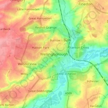
Nome: Mappa topografica Wellingborough, altitudine, rilievo.
Altitudine media: 76 m
Altitudine minima: 33 m
Altitudine massima: 120 m
Altre mappe topografiche
Clicca su una mappa per visualizzarne la topografia, l'altitudine e il rilievo.
Wellingborough
United Kingdom > England > North Northamptonshire > Great Doddington
Altitudine media: 83 m
Irchester Country Park
United Kingdom > England > North Northamptonshire > Little Irchester
Altitudine media: 60 m
River Nene Navigation
United Kingdom > England > North Northamptonshire > Irchester
Altitudine media: 55 m
Finedon
United Kingdom > England > North Northamptonshire
The town of Finedon rises to approximately 90 metres Above Ordinance Datum from the River Ise, with the historical centre of the settlement occupying a shallow south-west facing valley. The contemporary point of maximum elevation in the parish is the summit of the disused Sidegate Lane Landfill Site, located…
Altitudine media: 75 m
Irchester
United Kingdom > England > North Northamptonshire
The 12th-century English historian Henry of Huntingdon mentions a Roman "town on the river (Nene), in Huntingdonshire, which is entirely destroyed" as one of his interpretations of the 28 cities of Britain. The town is mentioned also by William Lambarde in Dictionarium Angliae Topographicum & Historicum.
Altitudine media: 62 m
King's Cliffe
United Kingdom > England > North Northamptonshire > King's Cliffe
Altitudine media: 69 m
Easton on the Hill
United Kingdom > England > North Northamptonshire > Easton on the Hill
Altitudine media: 71 m
Barton Seagrave
United Kingdom > England > North Northamptonshire
Other natives of the village include topographer John Bridges and his brother, Charles, a painter.
Altitudine media: 78 m
Irchester
United Kingdom > England > North Northamptonshire
The 12th-century English historian Henry of Huntingdon mentions a Roman "town on the river (Nene), in Huntingdonshire, which is entirely destroyed" as one of his interpretations of the 28 cities of Britain. The town is mentioned also by William Lambarde in Dictionarium Angliae Topographicum & Historicum.
Altitudine media: 62 m