
Fai una donazione
Equipaggiati per la tua prossima avventura:
In qualità di Affiliato Amazon, questo sito riceve una commissione sugli acquisti idonei, senza costi aggiuntivi per l’utente.
Mappa topografica Lerwick
Clicca sulla mappa per visualizzare l'altitudine.
Fai una donazione
Equipaggiati per la tua prossima avventura:
In qualità di Affiliato Amazon, questo sito riceve una commissione sugli acquisti idonei, senza costi aggiuntivi per l’utente.
Lerwick
Lerwick has transitioned from a subpolar oceanic climate (Cfc) to a maritime climate (Cfb) with cool to cold temperatures all year long. The lack of trees reflects the latter type. This is particularly pronounced by virtue of Lerwick being on the coast of an island, so even extreme temperature records are subdued; the record high stands at just 23.4 °C (74.1 °F) (July 1991) and the record low just −8.9 °C (16.0 °F) (January 1952 and January 1959). Lerwick is also a very cloudy town, averaging only 1,110 sunshine hours annually. February is the coldest month, with high temperatures averaging around 5.5 °C (41.9 °F). In August, the warmest month, average high temperatures are near 14.5 °C (58.1 °F). This produces an extremely narrow difference for an area north of the 60 parallel. In terms of average monthly precipitation, October to January are the year's wettest months, with over 140 mm (5.5 in) of precipitation each month; May and June are the driest months, with average monthly precipitation less than 60 mm (2.4 in) each. Snowfall can occur, primarily from December to March, but snow accumulation is rarely heavy and usually short-lived. The exposed North Atlantic location and proximity to autumn and winter storm tracks means high winds are a regular occurrence, alongside high levels of cloudiness and precipitation. Temperatures are likely to be slightly milder in the town centre at sea level, as the weather station is at an elevation of 82 metres (269 ft).
Fai una donazione
Equipaggiati per la tua prossima avventura:
In qualità di Affiliato Amazon, questo sito riceve una commissione sugli acquisti idonei, senza costi aggiuntivi per l’utente.
A proposito di questa mappa
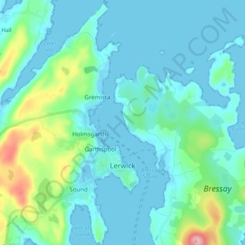
Nome: Mappa topografica Lerwick, altitudine, rilievo.
Luogo: Lerwick, Shetland, Scotland, United Kingdom (60.12851 -1.21367 60.20441 -1.13170)
Altitudine media: 34 m
Altitudine minima: -9 m
Altitudine massima: 225 m
Fai una donazione
Equipaggiati per la tua prossima avventura:
In qualità di Affiliato Amazon, questo sito riceve una commissione sugli acquisti idonei, senza costi aggiuntivi per l’utente.
Altre mappe topografiche
Clicca su una mappa per visualizzarne la topografia, l'altitudine e il rilievo.
Fai una donazione
Equipaggiati per la tua prossima avventura:
In qualità di Affiliato Amazon, questo sito riceve una commissione sugli acquisti idonei, senza costi aggiuntivi per l’utente.
Fai una donazione
Equipaggiati per la tua prossima avventura:
In qualità di Affiliato Amazon, questo sito riceve una commissione sugli acquisti idonei, senza costi aggiuntivi per l’utente.
Fai una donazione
Equipaggiati per la tua prossima avventura:
In qualità di Affiliato Amazon, questo sito riceve una commissione sugli acquisti idonei, senza costi aggiuntivi per l’utente.
Fai una donazione
Equipaggiati per la tua prossima avventura:
In qualità di Affiliato Amazon, questo sito riceve una commissione sugli acquisti idonei, senza costi aggiuntivi per l’utente.
Fai una donazione
Equipaggiati per la tua prossima avventura:
In qualità di Affiliato Amazon, questo sito riceve una commissione sugli acquisti idonei, senza costi aggiuntivi per l’utente.
Ronas Hill
United Kingdom > Scotland > Shetland
Ronas Hill (or Rönies Hill) is a hill in Shetland, Scotland. It is classed as a Marilyn, and is the highest point in the Shetland Islands at an elevation of 450 m (1,480 ft). A Neolithic chambered cairn is located near the summit.
Altitudine media: 298 m
Fai una donazione
Equipaggiati per la tua prossima avventura:
In qualità di Affiliato Amazon, questo sito riceve una commissione sugli acquisti idonei, senza costi aggiuntivi per l’utente.
Fai una donazione
Equipaggiati per la tua prossima avventura:
In qualità di Affiliato Amazon, questo sito riceve una commissione sugli acquisti idonei, senza costi aggiuntivi per l’utente.
Fai una donazione
Equipaggiati per la tua prossima avventura:
In qualità di Affiliato Amazon, questo sito riceve una commissione sugli acquisti idonei, senza costi aggiuntivi per l’utente.