
Mappa topografica Albstadt
Clicca sulla mappa per visualizzare l'altitudine.
Albstadt
Albstadt is spread across a variety of hills and valleys, its elevation ranges between 614 m (2,014 ft) above sea level and 966 m (3,169 ft). One valley is the river Schmiecha, a left-hand tributary of the Danube, a second valley is the river of upper Eyach, a tributary of the Neckar.
A proposito di questa mappa
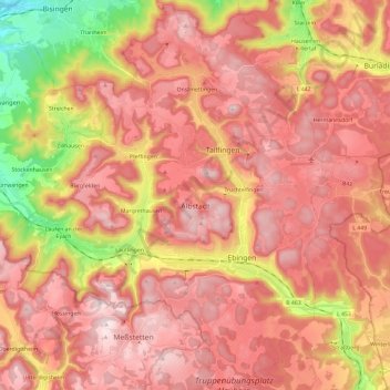
Nome: Mappa topografica Albstadt, altitudine, rilievo.
Altitudine media: 814 m
Altitudine minima: 511 m
Altitudine massima: 989 m
Altre mappe topografiche
Clicca su una mappa per visualizzarne la topografia, l'altitudine e il rilievo.