
Fai una donazione
Equipaggiati per la tua prossima avventura:
In qualità di Affiliato Amazon, questo sito riceve una commissione sugli acquisti idonei, senza costi aggiuntivi per l’utente.
Mappa topografica Charsadda
Clicca sulla mappa per visualizzare l'altitudine.
Fai una donazione
Equipaggiati per la tua prossima avventura:
In qualità di Affiliato Amazon, questo sito riceve una commissione sugli acquisti idonei, senza costi aggiuntivi per l’utente.
Charsadda
Chārsadda (Pashto: چارسده; pronounce; Urdu: چارسدہ; pronounce) is a town and headquarters of Charsadda District, in the Khyber Pakhtunkhwa province of Pakistan. It is the 85th-largest city of Pakistan, according to 2017 census. Located in the Valley of Peshawar, Charsadda lies about 29 kilometres (18 mi) from the provincial capital of Peshawar at an altitude of 276 metres (906 ft). The total area of Charsadda District measures about 996 square Km. The district is geographically organized into two primary parts: Hashtnagar (Pashto: Ashnaghar) and Do Aaba (Pashto: Duaba).
Fai una donazione
Equipaggiati per la tua prossima avventura:
In qualità di Affiliato Amazon, questo sito riceve una commissione sugli acquisti idonei, senza costi aggiuntivi per l’utente.
A proposito di questa mappa
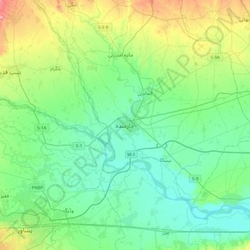
Nome: Mappa topografica Charsadda, altitudine, rilievo.
Altitudine media: 317 m
Altitudine minima: 285 m
Altitudine massima: 417 m
Fai una donazione
Equipaggiati per la tua prossima avventura:
In qualità di Affiliato Amazon, questo sito riceve una commissione sugli acquisti idonei, senza costi aggiuntivi per l’utente.
Altre mappe topografiche
Clicca su una mappa per visualizzarne la topografia, l'altitudine e il rilievo.
Swat
Pakistan > Khyber Pakhtunkhwa > Charsadda District > بانڈہ سیداں > بِجلۍ کورونه
Altitudine media: 370 m
Swat
Pakistan > Khyber Pakhtunkhwa > Charsadda District > بانڈہ سیداں > بِجلۍ کورونه
Altitudine media: 370 m