
Fai una donazione
Equipaggiati per la tua prossima avventura:
In qualità di Affiliato Amazon, questo sito riceve una commissione sugli acquisti idonei, senza costi aggiuntivi per l’utente.
Mappa topografica Mount Raleigh
Clicca sulla mappa per visualizzare l'altitudine.
Fai una donazione
Equipaggiati per la tua prossima avventura:
In qualità di Affiliato Amazon, questo sito riceve una commissione sugli acquisti idonei, senza costi aggiuntivi per l’utente.
Mount Raleigh
Mount Raleigh, elevation 3,132 m (10,276 ft), is one of the principal summits of the Pacific Ranges of the Coast Mountains of southern British Columbia in Canada. It is located just southeast of the confluence of the Southgate and Bishop Rivers, northeast of the head of Bute Inlet, and is the highest summit south of the Bishop River's divide with the Lillooet River at Ring Pass, which is at the southeastern edge of the Lillooet Icefield and just north of the Pemberton Icecap. It is also the highest peak south of the pass between the upper basins of Chilko Lake and the Taseko Lakes, just north of which is Monmouth Mountain at 3,182 m (10,440 ft) (see Tsʼilʔos Provincial Park).
Fai una donazione
Equipaggiati per la tua prossima avventura:
In qualità di Affiliato Amazon, questo sito riceve una commissione sugli acquisti idonei, senza costi aggiuntivi per l’utente.
A proposito di questa mappa
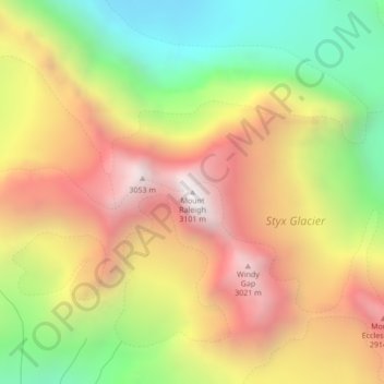
Nome: Mappa topografica Mount Raleigh, altitudine, rilievo.
Altitudine media: 2’414 m
Altitudine minima: 1’694 m
Altitudine massima: 3’109 m
Fai una donazione
Equipaggiati per la tua prossima avventura:
In qualità di Affiliato Amazon, questo sito riceve una commissione sugli acquisti idonei, senza costi aggiuntivi per l’utente.