
Fai una donazione
Equipaggiati per la tua prossima avventura:
In qualità di Affiliato Amazon, questo sito riceve una commissione sugli acquisti idonei, senza costi aggiuntivi per l’utente.
Mappa topografica Mangart Saddle
Clicca sulla mappa per visualizzare l'altitudine.
Fai una donazione
Equipaggiati per la tua prossima avventura:
In qualità di Affiliato Amazon, questo sito riceve una commissione sugli acquisti idonei, senza costi aggiuntivi per l’utente.
Mangart Saddle
Mangart Saddle or the Mangart Pass (Slovene: Mangartsko sedlo or Mangrtsko sedlo) is a mountain saddle in the Julian Alps in northwestern Slovenia. It has an elevation of 2,072 metres (6,798 ft). It is the most common starting point for the ascent of Mt. Mangart (2,679 m or 8,789 ft). The Mangart Road (Mangartska cesta) that leads over Mangart Saddle, with its elevation of 2,055 m (6,742 ft), has a number of turns and is the highest-lying road in Slovenia. It was built in 1938. The Mangart Pass offers a picturesque view towards the Log Koritnica Valley in Slovenia to the south and the Lakes of Fusine in Italy to the north. The Mangart Saddle Lodge (koča na Mangrtskem sedlu) lies under the saddle. The saddle was the scenery of the film Let's Go Our Own Way. Mangart Saddle is also known as the finding place of manganese nodules from the Early Jurassic period.
Fai una donazione
Equipaggiati per la tua prossima avventura:
In qualità di Affiliato Amazon, questo sito riceve una commissione sugli acquisti idonei, senza costi aggiuntivi per l’utente.
A proposito di questa mappa
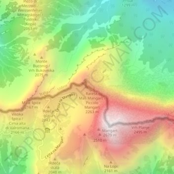
Nome: Mappa topografica Mangart Saddle, altitudine, rilievo.
Altitudine media: 1’780 m
Altitudine minima: 1’022 m
Altitudine massima: 2’663 m
Fai una donazione
Equipaggiati per la tua prossima avventura:
In qualità di Affiliato Amazon, questo sito riceve una commissione sugli acquisti idonei, senza costi aggiuntivi per l’utente.