
Mappa topografica Gilroy
Mappa interattiva
Clicca sulla mappa per visualizzare l'altitudine.
A proposito di questa mappa
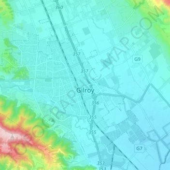
Nome: Mappa topografica Gilroy, altitudine, rilievo.
Luogo: Gilroy, Santa Clara County, California, United States (36.97025 -121.64280 37.04829 -121.51935)
Altitudine media: 106 m
Altitudine minima: 41 m
Altitudine massima: 597 m
Gilroy is located at 37°00′43″N 121°34′48″W / 37.012048°N 121.580080°W / 37.012048; -121.580080. It is approximately 26 km (16 mi) south of San Jose, California (Bailey Avenue (37.206770, -121.729150) to Monterey/Day Road (37.038210, -121.584480)) on U.S. Route 101 and 31 km (19 mi) inland from the Pacific Coast. Despite its apparent close proximity to San Jose, it is important to note that Gilroy City Hall lies at a distance of 33.3 miles from San Jose City Hall. Lying in a southern extension of the Santa Clara Valley at an elevation of about 61 m (200 ft) above MSL, it is bounded by the Santa Cruz Mountains to the west and the Diablo Range to the east. According to the United States Census Bureau, the city has a total area of 16.2 square miles (42 km2). 16.1 square miles (42 km2) of it is land and 0.06% is water.