
Mappa topografica Grand Rapids
Mappa interattiva
Clicca sulla mappa per visualizzare l'altitudine.
A proposito di questa mappa
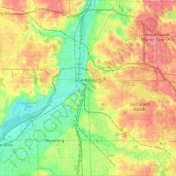
Nome: Mappa topografica Grand Rapids, altitudine, rilievo.
Luogo: Grand Rapids, Kent County, Michigan, United States (42.88365 -85.75153 43.02905 -85.56865)
Altitudine media: 216 m
Altitudine minima: 178 m
Altitudine massima: 257 m
Grand Rapids developed on the banks of the Grand River, where there was once a set of rapids, at an altitude of 610 feet (186 m) above sea level. Ships could navigate on the river up to this fall line, stopping because of the rapids. The river valley is flat and narrow, surrounded by steep hills and bluffs. The terrain becomes more rolling hills away from the river. The countryside surrounding the metropolitan area consists of mixed forest and farmland, with large areas of orchards to the northwest. It is approximately 25 mi (40 km) east of Lake Michigan. The state capital of Lansing lies about 70 mi (110 km) to the east-by-southeast, and Kalamazoo is about 50 mi (80 km) to the south.
Altre mappe topografiche
Clicca su una mappa per visualizzarne la topografia, l'altitudine e il rilievo.
Cole Lake
United States > Michigan > Kent County > Vergennes Township
Cole Lake, Vergennes Township, Kent County, Michigan, United States
Altitudine media: 253 m
Dean Lake
United States > Michigan > Kent County > Plainfield Charter Township
Dean Lake, Northview, Plainfield Charter Township, Kent County, Michigan, United States
Altitudine media: 228 m
Chase Lake
United States > Michigan > Kent County > Ada Township
Chase Lake, Ada Township, Kent County, Michigan, United States
Altitudine media: 256 m
Stoney Lake
United States > Michigan > Kent County > Lowell
Stoney Lake, Lowell, Kent County, Michigan, United States
Altitudine media: 203 m