
Mappa topografica Temple
Clicca sulla mappa per visualizzare l'altitudine.
A proposito di questa mappa
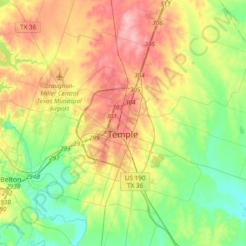
Nome: Mappa topografica Temple, altitudine, rilievo.
Luogo: Temple, Bell County, Texas, United States (31.00815 -97.55804 31.20906 -97.29137)
Altitudine media: 186 m
Altitudine minima: 136 m
Altitudine massima: 257 m
Altre mappe topografiche
Clicca su una mappa per visualizzarne la topografia, l'altitudine e il rilievo.
Belton
United States > Texas > Bell County > Belton > Belton
Belton is located 60 miles (97 km) north of Austin, 137 miles (220 km) south of Dallas, and 184 miles (296 km) west of Houston. It is near the center of Bell County at 31°3′32″N 97°27′48″W / 31.05889°N 97.46333°W / 31.05889; -97.46333 (31.058904, -97.463382). It is at the point where the…
Altitudine media: 176 m
Belton
United States > Texas > Bell County
Belton is located 60 miles (97 km) north of Austin, 137 miles (220 km) south of Dallas, and 184 miles (296 km) west of Houston. It is near the center of Bell County at 31°3′32″N 97°27′48″W / 31.05889°N 97.46333°W / 31.05889; -97.46333 (31.058904, –97.463382). Belton is at the point where…
Altitudine media: 179 m
Morgans Point Resort
United States > Texas > Bell County > Morgans Point Resort
Altitudine media: 201 m