
Fai una donazione
Equipaggiati per la tua prossima avventura:
In qualità di Affiliato Amazon, questo sito riceve una commissione sugli acquisti idonei, senza costi aggiuntivi per l’utente.
Mappa topografica Akron
Clicca sulla mappa per visualizzare l'altitudine.
Fai una donazione
Equipaggiati per la tua prossima avventura:
In qualità di Affiliato Amazon, questo sito riceve una commissione sugli acquisti idonei, senza costi aggiuntivi per l’utente.
Akron
Akron is located in the Great Lakes region about 39 miles (63 km) south of Lake Erie, on the Glaciated Allegheny Plateau. It is bordered by Cuyahoga Falls on the north and Barberton in the southwest. It is the center of the Akron metropolitan area which covers Summit and Portage Counties, and a principal city of the larger Cleveland–Akron–Canton Combined Statistical Area. Located on the western end of the plateau, the topography of Akron includes rolling hills and varied terrain. The Ohio and Erie Canal passes through the city, separating the east from west. Akron has the only biogas facility in the United States that produces methane through the decomposition process of sludge to create electricity. According to the 2010 census, the city has a total area of 62.37 square miles (161.5 km2), of which 62.03 square miles (160.7 km2) (or 99.45%) is land and 0.34 square miles (0.88 km2) (or 0.55%) is water.
Fai una donazione
Equipaggiati per la tua prossima avventura:
In qualità di Affiliato Amazon, questo sito riceve una commissione sugli acquisti idonei, senza costi aggiuntivi per l’utente.
A proposito di questa mappa
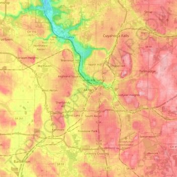
Nome: Mappa topografica Akron, altitudine, rilievo.
Luogo: Akron, Summit County, Ohio, United States (40.99766 -81.62101 41.17106 -81.40494)
Altitudine media: 315 m
Altitudine minima: 216 m
Altitudine massima: 377 m
Fai una donazione
Equipaggiati per la tua prossima avventura:
In qualità di Affiliato Amazon, questo sito riceve una commissione sugli acquisti idonei, senza costi aggiuntivi per l’utente.
Altre mappe topografiche
Clicca su una mappa per visualizzarne la topografia, l'altitudine e il rilievo.
Fai una donazione
Equipaggiati per la tua prossima avventura:
In qualità di Affiliato Amazon, questo sito riceve una commissione sugli acquisti idonei, senza costi aggiuntivi per l’utente.
Fai una donazione
Equipaggiati per la tua prossima avventura:
In qualità di Affiliato Amazon, questo sito riceve una commissione sugli acquisti idonei, senza costi aggiuntivi per l’utente.