
Mappa topografica Heidelberg
Clicca sulla mappa per visualizzare l'altitudine.
A proposito di questa mappa
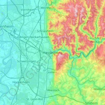
Nome: Mappa topografica Heidelberg, altitudine, rilievo.
Altitudine media: 200 m
Altitudine minima: 87 m
Altitudine massima: 602 m
Altre mappe topografiche
Clicca su una mappa per visualizzarne la topografia, l'altitudine e il rilievo.
Heidelberg Castle
Germany > Baden-Württemberg > Heidelberg > Königstuhl
All of these works are for the most part superficial and do not contain much information. In 1615, Merian's Topographia Palatinatus Rheni described Prince Elector Ludwig V as he "started building a new castle one hundred and more years ago". Most of the descriptions of the castle up until the 18th century are…
Altitudine media: 280 m