
Mappa topografica Worcester
Clicca sulla mappa per visualizzare l'altitudine.
A proposito di questa mappa
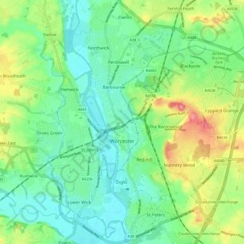
Nome: Mappa topografica Worcester, altitudine, rilievo.
Luogo: Worcester, Worcestershire, England, United Kingdom (52.16164 -2.26321 52.23139 -2.15730)
Altitudine media: 38 m
Altitudine minima: 10 m
Altitudine massima: 96 m
Altre mappe topografiche
Clicca su una mappa per visualizzarne la topografia, l'altitudine e il rilievo.
Upper Broadheath
United Kingdom > England > Worcestershire > Malvern Hills > Crown East
Altitudine media: 44 m
Malvern
United Kingdom > England > Worcestershire > Malvern Hills
Malvern lies in the Lower Severn/Avon plain affording it a degree of shelter caused by virtue of its nestling in between the Cotswold hills to the east, the Welsh Hills and Mountains to the west, and Birmingham plateau to the north. Although as with all the British Isles it has a maritime climate, the local…
Altitudine media: 95 m
Table Hill
United Kingdom > England > Worcestershire > Malvern Hills
Table Hill is situated in the range of Malvern Hills that runs about 13 kilometres (8 mi) north-south along the Herefordshire-Worcestershire border. It lies between North Hill and Sugarloaf Hill and has an elevation of 373 metres (1,224 ft).
Altitudine media: 188 m
Lickey Hills Country Park
United Kingdom > England > Worcestershire > Bromsgrove > Cofton Hackett CP
Altitudine media: 209 m
Morton Stanley Park
United Kingdom > England > Worcestershire > Redditch > Callow Hill
Altitudine media: 129 m
Stourport Historic Canal Basins
United Kingdom > England > Worcestershire > Wyre Forest > Stourport-on-Severn > Wilden
Altitudine media: 33 m
River Severn
United Kingdom > England > Worcestershire > Wyre Forest > Stourport-on-Severn
Altitudine media: 45 m
Kerswell Green
United Kingdom > England > Worcestershire > Malvern Hills > Kempsey
Altitudine media: 25 m
Lickey Hills Country Park
United Kingdom > England > Worcestershire > Birmingham > Rednal
Altitudine media: 226 m
Upper Wick
United Kingdom > England > Worcestershire > Malvern Hills District > Rushwick > Upper Wick
Altitudine media: 30 m
Welland Stone
United Kingdom > England > Worcestershire > Malvern Hills District
Altitudine media: 29 m
Upper Welland
United Kingdom > England > Worcestershire
Upper Welland is a small settled area within the civil parish of Malvern Wells, in Worcestershire, England. Lying close to the county boundaries of Herefordshire.It was formed when the upper part of Welland parish joined the newly created Malvern Hills Urban District. Welland Parish once stretched to the ridge…
Altitudine media: 115 m
Corse Lawn
United Kingdom > England > Worcestershire > Malvern Hills > Eldersfield
Altitudine media: 26 m
Shatterford
United Kingdom > England > Worcestershire > Wyre Forest > Upper Arley
Altitudine media: 124 m
Tanner's Green
United Kingdom > England > Worcestershire > Bromsgrove > Wythall CP
Altitudine media: 158 m
Beacon Wood
United Kingdom > England > Worcestershire > Bromsgrove > Lydiate Ash
Altitudine media: 210 m
Major's Green
United Kingdom > England > Worcestershire > Bromsgrove > Wythall CP
Altitudine media: 146 m
The Hill, Abberley
United Kingdom > England > Worcestershire > Malvern Hills > Abberley
Altitudine media: 132 m
Ronkswood Hill Meadows Local Nature Reserve
United Kingdom > England > Worcestershire > Worcester
Altitudine media: 56 m
Elcocks Brook
United Kingdom > England > Worcestershire > Redditch > Feckenham
Altitudine media: 101 m
Badsey Lane Nature Reserve
United Kingdom > England > Worcestershire > Wychavon > Evesham
Altitudine media: 37 m
Low Habberley
United Kingdom > England > Worcestershire > Wyre Forest > Ferndale
Altitudine media: 85 m
Elms Green
United Kingdom > England > Worcestershire > Malvern Hills > Abberley
Altitudine media: 121 m
Marlbrook
United Kingdom > England > Worcestershire > Bromsgrove > Lydiate Ash
Altitudine media: 177 m
Foley Park
United Kingdom > England > Worcestershire > Wyre Forest District > Foley Park
Altitudine media: 55 m
Menithwood
United Kingdom > England > Worcestershire > Malvern Hills District > Menithwood
Altitudine media: 122 m
Malvern
United Kingdom > England > Worcestershire > Malvern Hills
Malvern lies in the Lower Severn/Avon plain affording it a degree of shelter caused by virtue of its nestling in between the Cotswold hills to the east, the Welsh Hills and Mountains to the west, and Birmingham plateau to the north. Although as with all the British Isles it has a maritime climate, the local…
Altitudine media: 95 m