
Fai una donazione
Equipaggiati per la tua prossima avventura:
In qualità di Affiliato Amazon, questo sito riceve una commissione sugli acquisti idonei, senza costi aggiuntivi per l’utente.
Mappa topografica Hanbury
Clicca sulla mappa per visualizzare l'altitudine.
Fai una donazione
Equipaggiati per la tua prossima avventura:
In qualità di Affiliato Amazon, questo sito riceve una commissione sugli acquisti idonei, senza costi aggiuntivi per l’utente.
Hanbury
This locality adjoins the River Dove and includes a steep knoll between much of it and the river, Row Hill; five listed buildings are here all at Grade II. Hanbury's village centre is 0.9 miles (1.4 km) to the south. This hamlet is at an elevation of 61m AOD whereas the village centre of Hanbury is at the start of a steep westward valley at the source of the Salt Brook at 134m AOD.
Fai una donazione
Equipaggiati per la tua prossima avventura:
In qualità di Affiliato Amazon, questo sito riceve una commissione sugli acquisti idonei, senza costi aggiuntivi per l’utente.
A proposito di questa mappa
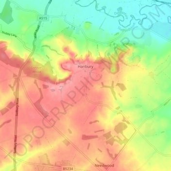
Nome: Mappa topografica Hanbury, altitudine, rilievo.
Altitudine media: 107 m
Altitudine minima: 52 m
Altitudine massima: 155 m
Fai una donazione
Equipaggiati per la tua prossima avventura:
In qualità di Affiliato Amazon, questo sito riceve una commissione sugli acquisti idonei, senza costi aggiuntivi per l’utente.
Altre mappe topografiche
Clicca su una mappa per visualizzarne la topografia, l'altitudine e il rilievo.
Burton upon Trent
United Kingdom > England > Staffordshire > East Staffordshire
Burton is about 109 miles (175 km) north west of London, about 30 miles north east of Birmingham, the UK's second largest city and about 23 miles east of the county town Stafford. It is at the easternmost border of the county of Staffordshire with Derbyshire, its suburbs and the course of the River Trent…
Altitudine media: 69 m
Tutbury Castle
United Kingdom > England > Staffordshire > East Staffordshire > Tutbury
Altitudine media: 66 m
Stubwood
United Kingdom > England > Staffordshire > East Staffordshire > Denstone
Altitudine media: 113 m
Birch Cross
United Kingdom > England > Staffordshire > East Staffordshire > Marchington
Altitudine media: 92 m
Fai una donazione
Equipaggiati per la tua prossima avventura:
In qualità di Affiliato Amazon, questo sito riceve una commissione sugli acquisti idonei, senza costi aggiuntivi per l’utente.
Gratwich
United Kingdom > England > Staffordshire > East Staffordshire > Kingstone
Altitudine media: 143 m
Fai una donazione
Equipaggiati per la tua prossima avventura:
In qualità di Affiliato Amazon, questo sito riceve una commissione sugli acquisti idonei, senza costi aggiuntivi per l’utente.
Marchington Woodlands
United Kingdom > England > Staffordshire > East Staffordshire
Altitudine media: 120 m
Blithfield Reservoir
United Kingdom > England > Staffordshire > East Staffordshire > Admaston
Altitudine media: 108 m
Fai una donazione
Equipaggiati per la tua prossima avventura:
In qualità di Affiliato Amazon, questo sito riceve una commissione sugli acquisti idonei, senza costi aggiuntivi per l’utente.
Harlow Wood
United Kingdom > England > Staffordshire > East Staffordshire > Upper Mayfield
Altitudine media: 177 m
Burton upon Trent
United Kingdom > England > Staffordshire > East Staffordshire
Burton is about 109 miles (175 km) north west of London, about 30 miles north east of Birmingham, the UK's second largest city and about 23 miles east of the county town Stafford. It is at the easternmost border of the county of Staffordshire with Derbyshire, its suburbs and the course of the River Trent…
Altitudine media: 69 m
Fai una donazione
Equipaggiati per la tua prossima avventura:
In qualità di Affiliato Amazon, questo sito riceve una commissione sugli acquisti idonei, senza costi aggiuntivi per l’utente.