Geolocalizza

Mappa topografica Botley Hill

Clicca sulla mappa per visualizzare l'altitudine.

Botley Hill

Botley Hill is a Marilyn (a hill with topographic prominence of at least 150m), and the third highest point in the county (after the peaks of Leith Hill south of Dorking and Gibbet Hill in Hindhead, both on the Greensand Ridge).

Wikipedia (CC-BY-SA 3.0)

A proposito di questa mappa

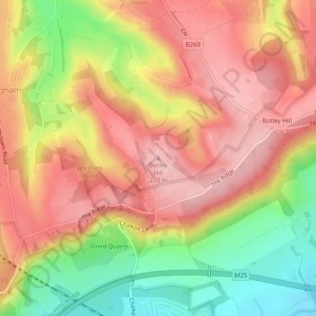
Nome: Mappa topografica Botley Hill, altitudine, rilievo.

Luogo: Botley Hill, Tandridge, Surrey, England, CR3 7AN, United Kingdom (51.27880 -0.01311 51.27890 -0.01301)

Altitudine media: 206 m

Altitudine minima: 109 m

Altitudine massima: 271 m

Altre mappe topografiche

Clicca su una mappa per visualizzarne la topografia, l'altitudine e il rilievo.

Oxted

United Kingdom > England > Surrey > Tandridge

Altitudine media: 128 m

Burstow

United Kingdom > England > Surrey > Tandridge

Altitudine media: 67 m

Warlingham

United Kingdom > England > Surrey > Tandridge

Elevations vary from 110m AOD at Woldingham Road, at the southernmost point of the parish, with a gentle increase in height through the village along the main road heading to the southeast, to the highest elevation (199.6m) at Limpsfield Road.

Altitudine media: 163 m

Tatsfield

United Kingdom > England > Surrey > Tandridge

Altitudine media: 176 m

Titsey

United Kingdom > England > Surrey > Tandridge

Altitudine media: 185 m

Crowhurst

United Kingdom > England > Surrey > Tandridge

Altitudine media: 62 m

Woldingham

United Kingdom > England > Surrey > Tandridge

Altitudine media: 183 m

Chaldon

United Kingdom > England > Surrey > Tandridge

Altitudine media: 181 m

Horne

United Kingdom > England > Surrey > Tandridge

Altitudine media: 68 m

Warlingham

United Kingdom > England > Surrey > Tandridge

Elevations vary from 110m AOD at Woldingham Road, at the southernmost point of the parish, with a gentle increase in height through the village along the main road heading to the southeast, to the highest elevation (199.6m) at Limpsfield Road.

Altitudine media: 163 m

Equipaggiati per la tua prossima avventura:

🎒Zaino Idrico MTB - Zaino compatto con sacca d'acqua integrata per ciclisti
💧Zaino con Sistema Idratazione - Zaino con sacca d’acqua integrata
🪶Cuscino da Viaggio - Cuscino leggero per riposo in natura
🥾Calze Tecniche per Trekking - Calze traspiranti e antivesciche per lunghe camminate
🌧️Poncho da Pioggia - Poncho impermeabile compatto per escursioni sotto la pioggia

In qualità di Affiliato Amazon, questo sito riceve una commissione sugli acquisti idonei, senza costi aggiuntivi per l’utente.