
Mappa topografica Sanbornton
Mappa interattiva
Clicca sulla mappa per visualizzare l'altitudine.
A proposito di questa mappa
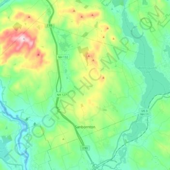
Nome: Mappa topografica Sanbornton, altitudine, rilievo.
Altitudine media: 228 m
Altitudine minima: 91 m
Altitudine massima: 599 m
According to the United States Census Bureau, the town has a total area of 49.7 square miles (128.6 km2), of which 47.4 sq mi (122.7 km2) are land and 2.3 sq mi (5.9 km2) are water, comprising 4.58% of the town. Bounded on the west by the Pemigewasset River and on the east by Lake Winnisquam, Sanbornton is largely drained by Salmon Brook, a tributary of the Pemigewasset. The highest point in town is the summit of Hersey Mountain, elevation 2,001 feet (610 m) above sea level, along the town's northwestern border.
Altre mappe topografiche
Clicca su una mappa per visualizzarne la topografia, l'altitudine e il rilievo.
Lake Winnipesaukee
United States > New Hampshire > Belknap County > Alton
Lake Winnipesaukee, Alton, Belknap County, New Hampshire, 03226, United States
Altitudine media: 223 m
The Plains
United States > New Hampshire > Belknap County > Tilton
The Plains, Tilton, Belknap County, New Hampshire, 03252, United States
Altitudine media: 167 m
Mallard Cove
United States > New Hampshire > Belknap County > Laconia
Mallard Cove, Laconia, Belknap County, New Hampshire, 03246, United States
Altitudine media: 173 m
Gilford
United States > New Hampshire > Belknap County
Gilford, Belknap County, New Hampshire, 03249, United States
Altitudine media: 231 m
Tilton
United States > New Hampshire > Belknap County
Tilton, Belknap County, New Hampshire, United States
Altitudine media: 196 m
Meredith
United States > New Hampshire > Belknap County
Meredith, Belknap County, New Hampshire, 03253, United States
Altitudine media: 215 m
Barnstead
United States > New Hampshire > Belknap County
Barnstead, Belknap County, New Hampshire, United States
Altitudine media: 221 m