
Fai una donazione
Equipaggiati per la tua prossima avventura:
In qualità di Affiliato Amazon, questo sito riceve una commissione sugli acquisti idonei, senza costi aggiuntivi per l’utente.
Mappa topografica Pahrump
Clicca sulla mappa per visualizzare l'altitudine.
Fai una donazione
Equipaggiati per la tua prossima avventura:
In qualità di Affiliato Amazon, questo sito riceve una commissione sugli acquisti idonei, senza costi aggiuntivi per l’utente.
Pahrump
Summers in Pahrump are generally very hot and dry, with occasional pushes of monsoonal moisture beginning in early July. Being at a similar elevation to Las Vegas, daytime highs in summer average within a few degrees lower than that of Las Vegas. Record highs are similar between the two cities as well. A typical day during June through August brings temperatures around 100 °F (38 °C), and occasionally 110 °F (43 °C). Nighttime temperatures, however, are noticeably cooler. This is due to the lack of an urban heat island in Pahrump, allowing for intense radiative cooling after sundown. As a result, summer nights are pleasantly warm, bottoming out in the mid-60s or 70s °F (around 20 °C). Pahrump's location in a valley leads to large diurnal temperature ranges, typically 30 °F (17 °C) but occasionally 40 °F (22 °C). By late August and early September, the sweltering summer heat noticeably tempers down. September is the gateway to fall, which brings very pleasant weather. October highs are generally 80 °F (27 °C) and nighttime temperatures in the 50s °F (low teens °C). Due to its elevation, Pahrump is protected from the searing summer temperatures experienced in the nearby Death Valley.
Fai una donazione
Equipaggiati per la tua prossima avventura:
In qualità di Affiliato Amazon, questo sito riceve una commissione sugli acquisti idonei, senza costi aggiuntivi per l’utente.
A proposito di questa mappa
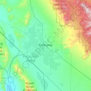
Nome: Mappa topografica Pahrump, altitudine, rilievo.
Luogo: Pahrump, Nye County, Nevada, United States (36.00121 -116.22802 36.40983 -115.89443)
Altitudine media: 1’141 m
Altitudine minima: 641 m
Altitudine massima: 3’143 m
Fai una donazione
Equipaggiati per la tua prossima avventura:
In qualità di Affiliato Amazon, questo sito riceve una commissione sugli acquisti idonei, senza costi aggiuntivi per l’utente.
Altre mappe topografiche
Clicca su una mappa per visualizzarne la topografia, l'altitudine e il rilievo.
Amargosa Valley
United States > Nevada > Nye County
Amargosa Valley is located at 36.58001 North, 116.44487 West at an elevation of 2,640 feet (805 m) above sea level. The landscape is typical of lower to moderate elevations in the Mojave Desert, with flat expanses of sandy soil punctuated by rocky mounds and hills. Predominant indigenous vegetation is White…
Altitudine media: 740 m
Devils Hole
United States > Nevada > Nye County
Devils Hole is a geothermal pool within a limestone cavern in the Amargosa Desert in the Amargosa Valley of Nevada, east over the Amargosa Range and Funeral Mountains from Death Valley. It is at an elevation of 730 m (2,400 ft) above sea level and the water is a constant temperature of 33 °C (91 °F). The…
Altitudine media: 756 m
Fai una donazione
Equipaggiati per la tua prossima avventura:
In qualità di Affiliato Amazon, questo sito riceve una commissione sugli acquisti idonei, senza costi aggiuntivi per l’utente.