
Mappa topografica Garfield Heights
Mappa interattiva
Clicca sulla mappa per visualizzare l'altitudine.
Garfield Heights
According to the United States Census Bureau, the city has a total area of 7.29 square miles (18.88 km2), of which 7.23 square miles (18.73 km2) is land and 0.06 square miles (0.16 km2) is water. The elevation of Garfield Heights is 831 feet (253 m) above sea level where it borders Cleveland, and its highest elevation is 972 feet (296 m) above sea level at the Garfield Heights Justice Center.
A proposito di questa mappa
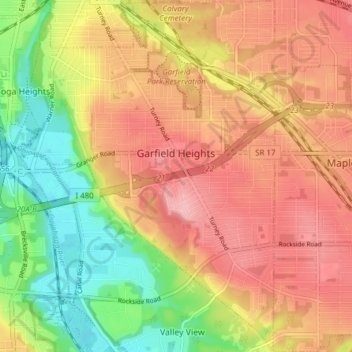
Nome: Mappa topografica Garfield Heights, altitudine, rilievo.
Altitudine media: 251 m
Altitudine minima: 178 m
Altitudine massima: 308 m
Altre mappe topografiche
Clicca su una mappa per visualizzarne la topografia, l'altitudine e il rilievo.
Cleveland
United States > Ohio > Cuyahoga County > Cleveland
The land rises quickly from the lake shore elevation of 569 feet. Public Square, less than one mile (1.6 km) inland, sits at an elevation of 650 feet (198 m), and Hopkins Airport, 5 miles (8 km) inland from the lake, is at an elevation of 791 feet (241 m).
Altitudine media: 219 m