
Mappa topografica Osage County
Mappa interattiva
Clicca sulla mappa per visualizzare l'altitudine.
A proposito di questa mappa
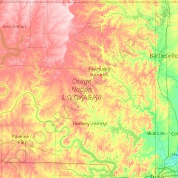
Nome: Mappa topografica Osage County, altitudine, rilievo.
Luogo: Osage County, Oklahoma, United States (36.16079 -97.06701 36.99929 -96.00046)
Altitudine media: 277 m
Altitudine minima: 175 m
Altitudine massima: 413 m
Holmes Peak is a mountain northwest of Tulsa in Osage County. It was named by the United States Board on Geographic Names on October 5, 1983 for the fictional detective, Sherlock Holmes. The name was proposed by Richard S. Warner. Holmes Peak is the highest point in the Tulsa Metropolitan area, with an elevation of 1,030 feet (310 m), though it ranks only as the 379th highest point in the state.
Altre mappe topografiche
Clicca su una mappa per visualizzarne la topografia, l'altitudine e il rilievo.
Skiatook
United States > Oklahoma > Osage County
Skiatook, Osage County, Oklahoma, 74070, United States
Altitudine media: 222 m
Foraker
United States > Oklahoma > Osage County
Foraker, Osage County, Oklahoma, United States
Altitudine media: 385 m
Fairfax
United States > Oklahoma > Osage County
Fairfax, Osage County, Oklahoma, United States
Altitudine media: 259 m
Herd
United States > Oklahoma > Osage County
Herd, Osage County, Oklahoma, United States
Altitudine media: 287 m