
Mappa topografica Cameron
Mappa interattiva
Clicca sulla mappa per visualizzare l'altitudine.
Cameron
Cameron is located in south-central Cameron Parish at 29°47′17″N 93°18′42″W / 29.78806°N 93.31167°W / 29.78806; -93.31167 (29.788055, -93.311764), along the Gulf of Mexico at an elevation of 4 feet (1.2 m) above sea level. State highways 27 and 82 pass through the community as Marshall Street, crossing the Calcasieu Ship Channel just west of town. Highway 82 leads east 93 miles (150 km) to Abbeville and west 48 miles (77 km) to Port Arthur, Texas. Highway 27 leads west then north 48 miles (77 km) to Sulphur. Lake Charles is 52 miles (84 km) to the north.
A proposito di questa mappa
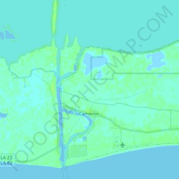
Nome: Mappa topografica Cameron, altitudine, rilievo.
Luogo: Cameron, Cameron Parish, Louisiana, 70631, United States (29.76080 -93.34742 29.86469 -93.21477)
Altitudine media: 2 m
Altitudine minima: -4 m
Altitudine massima: 8 m
Altre mappe topografiche
Clicca su una mappa per visualizzarne la topografia, l'altitudine e il rilievo.